File:Vandans St Anton im Montafon Panorama.jpg
Jump to navigation
Jump to search

Size of this preview: 800 × 199 pixels. Other resolutions: 320 × 80 pixels | 640 × 159 pixels | 1,024 × 255 pixels | 1,280 × 318 pixels | 7,654 × 1,904 pixels.
Original file (7,654 × 1,904 pixels, file size: 2.9 MB, MIME type: image/jpeg)
Captions
Captions
Add a one-line explanation of what this file represents
| Description |
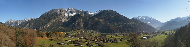
Deutsch: 180° Panoramablick vom Fusse des "Mutt". Im Vordergrund der Ort Vandans, hinten Sankt Anton im Montafon. Der Gebirgszug Links mit der Elsspitze 1.980m, Stierkopf 1.801m und der Gamsfreiheit 2.211m gehören zum Lechquellengebirge in der Mitte die Itonskopfgruppe im westlichen Verwallgebirge v.l.n.r. 1.Davennakopf 1.708m, 2.Davenna 1.881m, 3.Zwölferkopf 1.843m, 4.Wannakopf 2.032m, 5.Rellseck 1.487m. In der rechten Bildhälfte das Skigebiet Hochjoch, Zamang mit der Gebirgskette v.l.n.r. 1.Vorderkapell 1.874m, 2.Wormser Hütte 2.307m, 3.Hochjoch 2.520m, 4.Kreuzjoch 2.380m, 5.Zamangspitze. Rechts die weisse Spitze ist die Valschavieler Maderer 2.769m, ebenfalls in der Verwallgruppe. |
| Date | |
| Source | Own work |
| Author | böhringer friedrich |
| Permission (Reusing this file) |
I, the copyright holder of this work, hereby publish it under the following license: This file is licensed under the Creative Commons Attribution-Share Alike 2.5 Generic license.
|
This Photo was taken by Böhringer Friedrich.
|
Feel free to use my photos, but please mention me as the author and if you want send me a message. or (rufre@lenz-nenning.at) |
| Camera location | | View this and other nearby images on: OpenStreetMap |
|---|
File history
Click on a date/time to view the file as it appeared at that time.
| Date/Time | Thumbnail | Dimensions | User | Comment | |
|---|---|---|---|---|---|
| current | 22:07, 19 November 2008 | 7,654 × 1,904 (2.9 MB) | Böhringer (talk | contribs) | {{Information |Description= {{de| 180° Panoramablick vom Fusse des "Mutt". Im Vordergrund der Ort Vandans, hinten Sankt Anton im Montafon. Der Gebirgszug '''Links''' mit der Elsspitze 1.980 | |
| 08:31, 18 November 2008 | 7,654 × 1,904 (2.92 MB) | Böhringer (talk | contribs) | {{Information |Description= {{de| 180° Panoramablick vom Fusse des "Mutt". Im Vordergrund der Ort Vandans hinten Sankt Anton im Montafon. }} |Source= own work |Date= 2008-11-15 |Author= [[U |
You cannot overwrite this file.
File usage on Commons
The following 3 pages use this file:
File usage on other wikis
The following other wikis use this file:
- Usage on de.wikipedia.org
- Usage on fr.wikivoyage.org
- Usage on www.wikidata.org