File:Uryankhay-Tuva AO.png
Jump to navigation
Jump to search

Size of this preview: 800 × 498 pixels. Other resolutions: 320 × 199 pixels | 640 × 399 pixels | 1,024 × 638 pixels | 1,599 × 996 pixels.
Original file (1,599 × 996 pixels, file size: 24 KB, MIME type: image/png)
Captions
Captions
Add a one-line explanation of what this file represents
Summary[edit]
| Description |
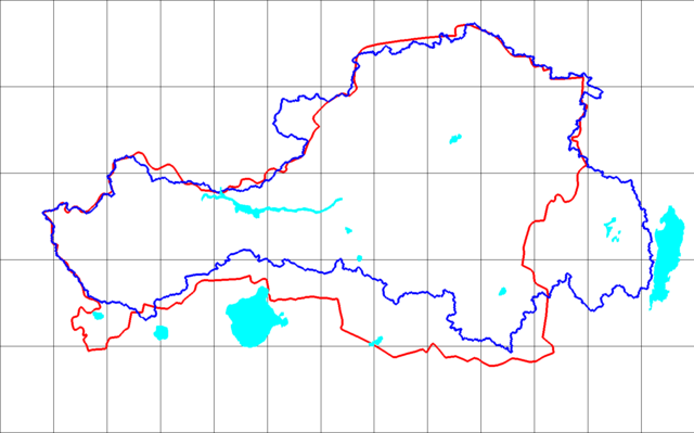
English: Blue line is the Uriankhay (1914) border line (reconstructed using SRTM mission DEM) as upper Yenisey watershed area plus upper Us and Kantegir river valleys. Red line is the Tuva Autonomous Oblast boundary line reprojected and vectorized from the Soviet atlas (1954 issue) with boundaries as of 1953. Русский: Синяя линия - линия границы Урянхай (1914 г.) (реконструированная с использованием ЦМР миссии SRTM) как верхняя часть водораздела Енисея плюс верхняя часть долин рек Ус и Кантегир. Красная линия - линия границы Тувинской автономной области, воспроизведенная и векторизованная из советского атласа (выпуск 1954 г.) с границами по состоянию на 1953 г. Français : Kraï d'Ouriankhaï en 1914 : ligne bleue, selon SRTM mission DEM dans les hautes vallées du Ïenisseï, de l'Ous et de la Kanteguir. Oblast autonome touvaine au sein de la RSFSR : ligne rouge, vectorisée d'après l'Atlas soviétique de 1954 montrant les limites de 1953. |
| Date | |
| Source | Soviet atlas (1954 issue) with boundaries as of 1953 by Bogomolov.PL. |
| Author | Bogomolov.PL |
| Permission (Reusing this file) |
Bogomolov.PL's map: Own work. |
top left corner is 54N 88E bottom right corner is 49N 101E
Licensing[edit]
| I, the copyright holder of this work, release this work into the public domain. This applies worldwide. In some countries this may not be legally possible; if so: I grant anyone the right to use this work for any purpose, without any conditions, unless such conditions are required by law. |
File history
Click on a date/time to view the file as it appeared at that time.
| Date/Time | Thumbnail | Dimensions | User | Comment | |
|---|---|---|---|---|---|
| current | 12:33, 27 June 2021 | | 1,599 × 996 (24 KB) | Bogomolov.PL (talk | contribs) | revert to the original version as it is properly copyrighted |
| 14:51, 20 June 2021 |  | 1,599 × 996 (183 KB) | Claude Zygiel (talk | contribs) | Nasa grey background {{Image-GFDL-GMT|migration=relicense}} | |
| 22:33, 17 January 2009 |  | 1,599 × 996 (24 KB) | Bogomolov.PL (talk | contribs) | {{Information |Description={{en|1=Blue line is the Uriankhay (1914) border line (reconstructed using SRTM mission DEM) as upper Yenisey watershed area plus upper Us and Kantegir river valleys. Red line is the Tuva Autonomous Oblast boundary line reprojec |
You cannot overwrite this file.
File usage on Commons
The following page uses this file:
File usage on other wikis
The following other wikis use this file:
- Usage on be-tarask.wikipedia.org
- Usage on bg.wikipedia.org
- Usage on ce.wikipedia.org
- Usage on cs.wikipedia.org
- Usage on de.wikipedia.org
- Usage on en.wikipedia.org
- Usage on es.wikipedia.org
- Usage on fa.wikipedia.org
- Usage on fr.wikipedia.org
- Usage on hu.wikipedia.org
- Usage on id.wikipedia.org
- Usage on it.wikipedia.org
- Usage on lt.wikipedia.org
- Usage on nl.wikipedia.org
- Usage on pl.wikipedia.org
- Tuwa
- Wikipedia:Głupie dowcipy i czysty bezsens/Geografia dla każdego
- Wikipedysta:Litwin Gorliwy/Gupoty
- Rosyjska kolonizacja i podbój Tuwy
- Wikipedysta:TheTNT1500/Kraj Urianchajski
- Wikipedysta:Malarz pl/szablony/Państwo infobox
- Wikipedysta:Malarz pl/szablony/Państwo infobox/13
- Wikipedysta:Malarz pl/szablony/Państwo infobox/16
- Wikipedia:Głupie dowcipy i czysty bezsens/Historia tom I
- Wikipedysta:Malarz pl/szablony/Państwo infobox/29
- Wikipedysta:Malarz pl/szablony/Państwo infobox/30
- Usage on pt.wikipedia.org
- Usage on ru.wikipedia.org
- Usage on sah.wikipedia.org
View more global usage of this file.