File:Unterföhring Kreisstraße M3 Aerial.jpg
Jump to navigation
Jump to search
Size of this preview: 800 × 534 pixels. Other resolutions: 320 × 213 pixels | 640 × 427 pixels | 1,045 × 697 pixels.
Original file (1,045 × 697 pixels, file size: 152 KB, MIME type: image/jpeg)
Captions
Captions
Add a one-line explanation of what this file represents
Summary
[edit]
| Description |
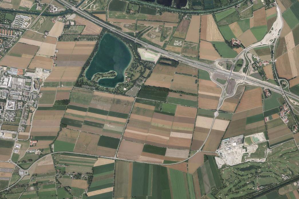
Deutsch: Luftbild der Kreisstraße M 3 auf dem Gemeindegebiet von Unterföhring bei München, Oberbayern. In der oberen rechten Bildhälfte Anschlussstelle Aschheim/Ismaning der Bundesautobahn 99 in der Bauphase. In der Bildmitte das Naherholungsgebiet Feringasee. |
| Date | |
| Source | http://vermessung.bayern.de/opendata |
| Author | Bayerische Vermessungsverwaltung – www.geodaten.bayern.de |
Licensing
[edit]
This file is licensed under the Creative Commons Attribution-Share Alike 3.0 Unported license.
- You are free:
- to share – to copy, distribute and transmit the work
- to remix – to adapt the work
- Under the following conditions:
- attribution – You must give appropriate credit, provide a link to the license, and indicate if changes were made. You may do so in any reasonable manner, but not in any way that suggests the licensor endorses you or your use.
- share alike – If you remix, transform, or build upon the material, you must distribute your contributions under the same or compatible license as the original.
File history
Click on a date/time to view the file as it appeared at that time.
| Date/Time | Thumbnail | Dimensions | User | Comment | |
|---|---|---|---|---|---|
| current | 16:06, 14 October 2016 | | 1,045 × 697 (152 KB) | Rudolph Buch (talk | contribs) | User created page with UploadWizard |
You cannot overwrite this file.
File usage on Commons
The following page uses this file:
File usage on other wikis
The following other wikis use this file:
- Usage on de.wikipedia.org