File:United Kingdom labelled map7.png
Jump to navigation
Jump to search

Size of this preview: 358 × 599 pixels. Other resolutions: 143 × 240 pixels | 287 × 480 pixels | 643 × 1,075 pixels.
Original file (643 × 1,075 pixels, file size: 86 KB, MIME type: image/png)
Captions
Captions
Add a one-line explanation of what this file represents

|
File:United Kingdom labelled map7 vector.svg is a vector version of this file. It should be used in place of this PNG file when not inferior.
File:United Kingdom labelled map7.png → File:United Kingdom labelled map7 vector.svg
For more information, see Help:SVG. |
 |
Summary[edit]
| Description |
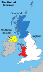
English: Divisions of the United Kingdom |
||
| Date | 17 July 2008 (original upload date) | ||
| Source |
Own work by Matt Lewis derived from: File:Uk map home nations.png |
||
| Author | Amended Wikipedia image - amended by Matt Lewis for Wikipedia. | ||
| Permission (Reusing this file) |
Matt Lewis, the copyright holder of this work, hereby publishes it under the following licenses: This file is licensed under the Creative Commons Attribution-Share Alike 3.0 Unported license. Attribution: Matt Lewis
You may select the license of your choice. |
||
| Other versions |
|

Original upload log[edit]
The original description page was on en.wikipedia (log). All following user names refer to en.wikipedia.
- 17:17, 1 December 2008 Ddstretch 643×1,075 (86 KB) (Reverted to version as of 02:16, 17 July 2008- colors as used were agreed upon by consensus, and green is clearly too political to stay)
- 16:35, 1 December 2008 Roadnote 643×1,075 (72 KB) (Original by [[User:Matt Lewis|Matt Lewis]] ([[User talk:Matt Lewis|talk]]) - Northern Ireland changed from yellow to green by ~~~~ {{ShouldBeSVG}})
- 02:16, 17 July 2008 Matt Lewis 643×1,075 (86 KB) (Amended Wikipedia image - amended by [[User:Matt Lewis|Matt Lewis]] for Wikipedia.)
File history
Click on a date/time to view the file as it appeared at that time.
| Date/Time | Thumbnail | Dimensions | User | Comment | |
|---|---|---|---|---|---|
| current | 21:59, 8 December 2013 | | 643 × 1,075 (86 KB) | Chronus (talk | contribs) | Reverted to version as of 20:04, 7 December 2013 |
| 20:05, 7 December 2013 |  | 643 × 1,075 (516 KB) | Boonstiffs (talk | contribs) | Reverted to version as of 20:03, 7 December 2013 | |
| 20:04, 7 December 2013 |  | 643 × 1,075 (86 KB) | Boonstiffs (talk | contribs) | Reverted to version as of 05:59, 27 October 2013 | |
| 20:03, 7 December 2013 |  | 643 × 1,075 (516 KB) | Boonstiffs (talk | contribs) | Reverted to version as of 12:59, 26 October 2013 | |
| 05:59, 27 October 2013 |  | 643 × 1,075 (86 KB) | Tóraí (talk | contribs) | Reverted to version as of 11:31, 12 July 2009; map is used on articles relating to the 4 "countries of the United Kingdom", where Cornwall isn't usually considered one | |
| 12:59, 26 October 2013 |  | 643 × 1,075 (516 KB) | Mownberry (talk | contribs) | Cornwall added. | |
| 11:31, 12 July 2009 |  | 643 × 1,075 (86 KB) | Chronus (talk | contribs) | == Summary == {{Information |Description=Divisions of the United Kingdom |Source=originally uploaded to :en at en:File:United Kingdom labelled map7.png |Date= |Author= Amended Wikipedia image - amended by Matt Lewis for Wikipe |
You cannot overwrite this file.
File usage on Commons
The following page uses this file:
File usage on other wikis
The following other wikis use this file:
- Usage on en.wikipedia.org