File:Umgebung von Strassburg 1883.jpg
Jump to navigation
Jump to search

Size of this preview: 412 × 599 pixels. Other resolutions: 165 × 240 pixels | 330 × 480 pixels | 528 × 768 pixels | 1,146 × 1,666 pixels.
Original file (1,146 × 1,666 pixels, file size: 605 KB, MIME type: image/jpeg)
Captions
Captions
Add a one-line explanation of what this file represents
Summary[edit]
| Description |
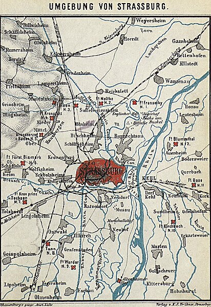
Français : Carte des environs de Strasbourg en 1883. Ce plan mentionne les forts environnant Strasbourg Deutsch: Karte der Umgebung von Strassburg in 1883. Man kann die Forts sehen. |
| Date | |
| Source | Bibliothèque nationale et universitaire de Strasbourg (en ligne sur Numistral) |
| Author | Mündel Curt (Schauenburg's Geographische Anstalt) |
Licensing[edit]
| This file is licensed under the Licence Ouverte 1.0 (License text, English license text).
|
File history
Click on a date/time to view the file as it appeared at that time.
| Date/Time | Thumbnail | Dimensions | User | Comment | |
|---|---|---|---|---|---|
| current | 16:49, 22 June 2012 | | 1,146 × 1,666 (605 KB) | Paralacre (talk | contribs) | sans les bordures |
| 20:19, 28 February 2012 |  | 1,250 × 1,961 (703 KB) | Paralacre (talk | contribs) |
You cannot overwrite this file.
File usage on Commons
There are no pages that use this file.
File usage on other wikis
The following other wikis use this file:
- Usage on de.wikipedia.org
- Usage on fr.wikipedia.org