File:Umbria Plantation 08.jpg
Jump to navigation
Jump to search
Size of this preview: 800 × 564 pixels. Other resolutions: 320 × 225 pixels | 640 × 451 pixels | 948 × 668 pixels.
Original file (948 × 668 pixels, file size: 157 KB, MIME type: image/jpeg)
Captions
Captions
Add a one-line explanation of what this file represents
| Description |
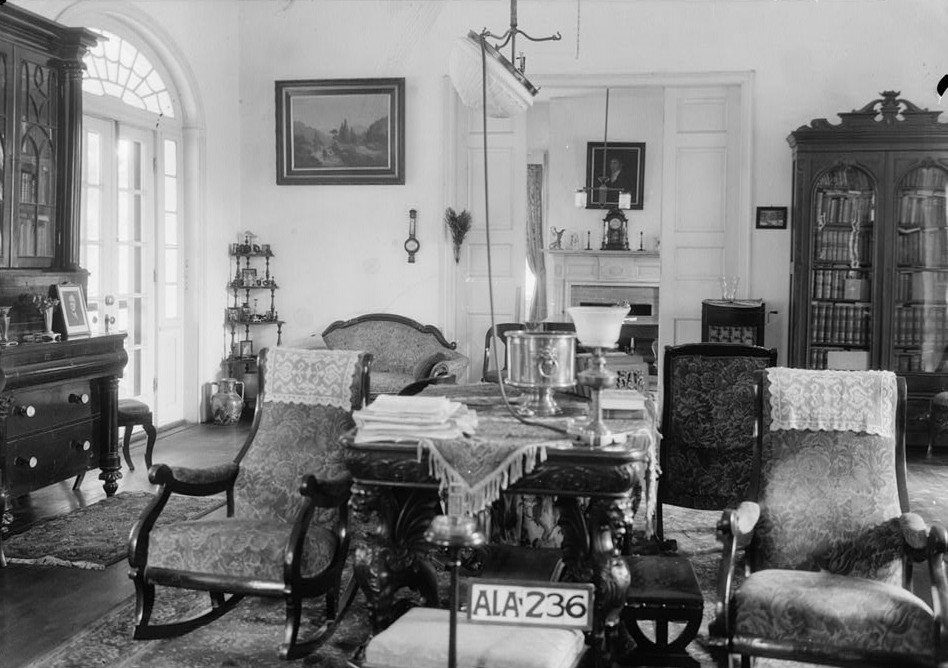
English: Governor Samuel Pickens House, best known as Umbria, State Route 14, Sawyerville vicinity, Hale, AL. VIEW OF LIVING ROOM LOOKING E. INTO THE DINING ROOM. Completed circa 1830 for Samuel Pickens, destroyed by fire on December 30, 1971. |
|||||
| Date | ||||||
| Source |
Historic American Buildings Survey, Library of Congress, Prints & Photographs Division, HABS [or HAER or HALS], Reproduction number "HABS ALA,33-SAWV.V,1-22"
|
|||||
| Author | Alex Bush | |||||
| Permission (Reusing this file) |
|


| Camera location | | View this and other nearby images on: OpenStreetMap |
|---|
File history
Click on a date/time to view the file as it appeared at that time.
| Date/Time | Thumbnail | Dimensions | User | Comment | |
|---|---|---|---|---|---|
| current | 04:04, 26 December 2010 | | 948 × 668 (157 KB) | Altairisfar (talk | contribs) | {{Information |Description={{en|'''Governor Samuel Pickens House''', best known as '''Umbria''', State Route 14, Sawyerville vicinity, Hale, AL. VIEW OF LIVING ROOM LOOKING E. INTO THE DINING ROOM. Completed circa 1830 for Samuel Pickens, destroyed by fir |
You cannot overwrite this file.
File usage on Commons
There are no pages that use this file.