File:US wind power map.png
Jump to navigation
Jump to search
Size of this preview: 800 × 505 pixels. Other resolutions: 320 × 202 pixels | 640 × 404 pixels | 1,130 × 713 pixels.
Original file (1,130 × 713 pixels, file size: 163 KB, MIME type: image/png)
Captions
Captions
Add a one-line explanation of what this file represents
Summary[edit]
| Description |
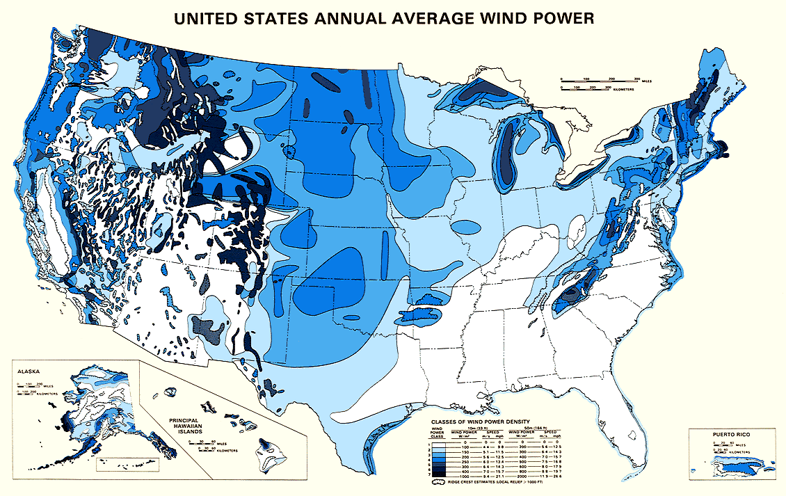
English: Map showing estimated wind resources for the United States. |
| Date | |
| Source | http://rredc.nrel.gov/wind/pubs/atlas/maps/chap2/2-01m.html |
| Author | National Renewable Energy Laboratory |
| Permission (Reusing this file) |
EERE copyright policy says its works are public domain: http://www1.eere.energy.gov/webpolicies/#copyright |
| Other versions | an updated version of this map, also showing transmission lines, is in: File:United States Wind Resources and Transmission Lines map.jpg |
- 'Source: English Wikipedia, original upload 5 November 2004 by Iain.mcclatchie en:Image:US wind power map.png
Licensing[edit]
| This image is a work of a United States Department of Energy (or predecessor organization) employee, taken or made as part of that person's official duties. As a work of the U.S. federal government, the image is in the public domain.
Please note that national laboratories operate under varying licences and some are not free. Check the site policies of any national lab before crediting it with this tag.
|

|
File history
Click on a date/time to view the file as it appeared at that time.
| Date/Time | Thumbnail | Dimensions | User | Comment | |
|---|---|---|---|---|---|
| current | 18:12, 4 December 2005 | | 1,130 × 713 (163 KB) | Saperaud~commonswiki (talk | contribs) | *'''Description:''' U.S. wind power map. Source: United States National Renewable Energy Laboratory [http://rredc.nrel.gov/wind/pubs/atlas/maps/chap2/2-01m.html] *''''Source:''' English Wikipedia, original upload 5 November 2004 by [[:en:User:Iain.mcclat |
You cannot overwrite this file.
File usage on Commons
The following page uses this file:
File usage on other wikis
The following other wikis use this file:
- Usage on fa.wikipedia.org
- Usage on fr.wikipedia.org
- Usage on fr.wikibooks.org
- Usage on he.wikipedia.org
- Usage on ht.wikipedia.org
- Usage on ja.wikipedia.org
- Usage on ru.wikipedia.org