File:US nuclear sites map.svg
Jump to navigation
Jump to search

Size of this PNG preview of this SVG file: 800 × 508 pixels. Other resolutions: 320 × 203 pixels | 640 × 407 pixels | 1,024 × 651 pixels | 1,280 × 813 pixels | 2,560 × 1,626 pixels | 913 × 580 pixels.
Original file (SVG file, nominally 913 × 580 pixels, file size: 285 KB)
Captions
Captions
Add a one-line explanation of what this file represents
Summary[edit]
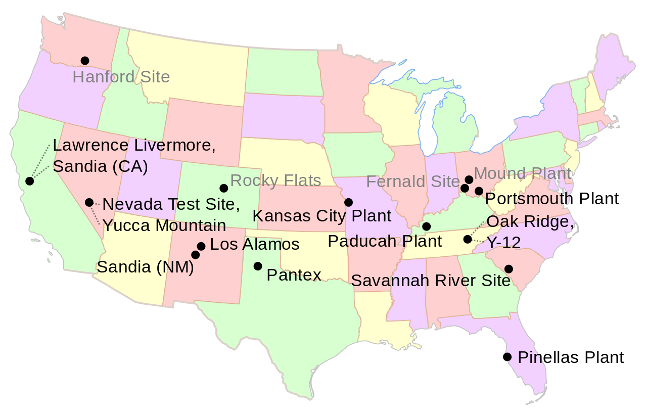
Map of major U.S. nuclear weapons infrastructure sites during the Cold War and into the present. Places with grayed-out names are no longer functioning and are in various stages of environmental remediation.
Created using Image:Map of USA with state names.svg as a base. See that link for the full attribution details.
This derived map created by User:Fastfission with Inkscape.
This W3C-unspecified vector image was created with Inkscape .
Licensing[edit]
Created by User:Fastfission (credit: "Wikimedia Commons") based on a map by User:Wapcaplet.
I, the copyright holder of this work, hereby publish it under the following licenses:

|
Permission is granted to copy, distribute and/or modify this document under the terms of the GNU Free Documentation License, Version 1.2 or any later version published by the Free Software Foundation; with no Invariant Sections, no Front-Cover Texts, and no Back-Cover Texts. A copy of the license is included in the section entitled GNU Free Documentation License. |
| This file is licensed under the Creative Commons Attribution-Share Alike 3.0 Unported license. | ||
| ||
| This licensing tag was added to this file as part of the GFDL licensing update. |
This file is licensed under the Creative Commons Attribution 2.5 Generic license.
- You are free:
- to share – to copy, distribute and transmit the work
- to remix – to adapt the work
- Under the following conditions:
- attribution – You must give appropriate credit, provide a link to the license, and indicate if changes were made. You may do so in any reasonable manner, but not in any way that suggests the licensor endorses you or your use.
You may select the license of your choice.
File history
Click on a date/time to view the file as it appeared at that time.
| Date/Time | Thumbnail | Dimensions | User | Comment | |
|---|---|---|---|---|---|
| current | 15:13, 8 November 2009 | | 913 × 580 (285 KB) | Fastfission~commonswiki (talk | contribs) | fix Savannah River Site |
| 15:11, 8 November 2009 |  | 913 × 580 (285 KB) | Fastfission~commonswiki (talk | contribs) | fix font, update metadata | |
| 03:13, 21 August 2006 |  | 913 × 580 (284 KB) | Fastfission~commonswiki (talk | contribs) | remove background and non-contiguous states (not necessary for this, clutters image) | |
| 03:01, 21 August 2006 |  | 959 × 593 (319 KB) | Fastfission~commonswiki (talk | contribs) | Map of major U.S. nuclear weapons infrastructure sites during the Cold War and into the present. Places with grayed-out names are no longer functioning and are in various stages of environmental remediation. Created using [[:Image:Map of USA with state n |
You cannot overwrite this file.
File usage on Commons
There are no pages that use this file.
File usage on other wikis
The following other wikis use this file:
- Usage on en.wikipedia.org
- Usage on es.wikipedia.org
- Usage on fr.wikipedia.org