File:US congressional redistricting methods, post-2020 census.svg
Jump to navigation
Jump to search

Size of this PNG preview of this SVG file: 800 × 495 pixels. Other resolutions: 320 × 198 pixels | 640 × 396 pixels | 1,024 × 633 pixels | 1,280 × 791 pixels | 2,560 × 1,583 pixels | 959 × 593 pixels.
Original file (SVG file, nominally 959 × 593 pixels, file size: 57 KB)
Captions
Captions
Add a one-line explanation of what this file represents
Summary[edit]
| Description |
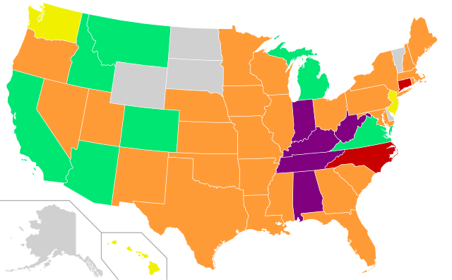
English: A map of the United States showing each state's redistricting methods after the 2020 census
Independent commission
Politician commission
Passed by legislature with gubernatorial approval
Passed by legislature, governor plays no role
Passed by legislature, simple majority veto override
Not applicable due to having one at-large district Español: Un mapa de los Estados Unidos que muestra los métodos de redistribución de distritos de cada estado después del censo de 2020
Comisión independiente
Comisión política
Aprobado por la legislatura con la aprobación del gobernador
Aprobado por la legislatura, el gobernador no juega ningún rol
Aprobado por la legislatura, anulación del veto por mayoría simple
No aplicable debido a que tiene un distrito general |
| Date | |
| Source | Derived from Blank US Map (states only).svg and Congressional redistricting methods, 2022.png |
| Author | JayCoop |
| SVG development | This map was created with a text editor. |

.svg)
Licensing[edit]
| This file is made available under the Creative Commons CC0 1.0 Universal Public Domain Dedication. | |
| The person who associated a work with this deed has dedicated the work to the public domain by waiving all of their rights to the work worldwide under copyright law, including all related and neighboring rights, to the extent allowed by law. You can copy, modify, distribute and perform the work, even for commercial purposes, all without asking permission.
|
File history
Click on a date/time to view the file as it appeared at that time.
| Date/Time | Thumbnail | Dimensions | User | Comment | |
|---|---|---|---|---|---|
| current | 09:00, 5 February 2022 | | 959 × 593 (57 KB) | EmmaCoop (talk | contribs) | Correcting Washington |
| 04:03, 30 January 2022 |  | 959 × 593 (57 KB) | EmmaCoop (talk | contribs) | Uploaded own work with UploadWizard |
You cannot overwrite this file.
File usage on Commons
The following 3 pages use this file:
File usage on other wikis
The following other wikis use this file:
- Usage on en.wikipedia.org
- Usage on hu.wikipedia.org