File:USGS - 1971 San Fernando earthquake - Scarp at Foothill Nursing Home - Street level view.jpg
Jump to navigation
Jump to search

Size of this preview: 615 × 600 pixels. Other resolutions: 246 × 240 pixels | 492 × 480 pixels | 788 × 768 pixels | 1,050 × 1,024 pixels | 1,400 × 1,365 pixels.
Original file (1,400 × 1,365 pixels, file size: 1.14 MB, MIME type: image/jpeg)
Captions
Captions
Add a one-line explanation of what this file represents
Summary[edit]
| Description |
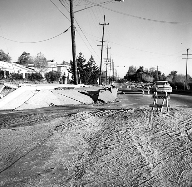
English: San Fernando Earthquake, February 9, 1971, 6:01am PST. [Location centered at 34 degrees 24.67 minutes north, 118 degrees 24.04 west. Magnitude 6.6. Depth 8.4 km. The total surface rupture was roughly 19 km long with a maximum slip of 2 meters. Also known as the Sylmar Earthquake. This earthquake caused $500 million in property damage and 65 deaths, most deaths occurred at the Veteran's Administration Hospital.] Scarp in front of Foothill Nursing Home on Foothill Blvd, near Vaughn Street. The Nursing Home pictured was extensively damaged during the quake. View towards southeast. Feb 11, 1971. |
| Date | |
| Source | [1] |
| Author | USGS (Wallace, R.E.) |
Licensing[edit]
This image is in the public domain in the United States because it only contains materials that originally came from the United States Geological Survey, an agency of the United States Department of the Interior. For more information, see the official USGS copyright policy.
|
File history
Click on a date/time to view the file as it appeared at that time.
| Date/Time | Thumbnail | Dimensions | User | Comment | |
|---|---|---|---|---|---|
| current | 15:41, 31 March 2013 | | 1,400 × 1,365 (1.14 MB) | Dawnseeker2000 (talk | contribs) | User created page with UploadWizard |
You cannot overwrite this file.
File usage on Commons
There are no pages that use this file.
File usage on other wikis
The following other wikis use this file:
- Usage on en.wikipedia.org