File:USA Utah location map.svg
Jump to navigation
Jump to search

Size of this PNG preview of this SVG file: 505 × 600 pixels. Other resolutions: 202 × 240 pixels | 404 × 480 pixels | 647 × 768 pixels | 862 × 1,024 pixels | 1,724 × 2,048 pixels | 868 × 1,031 pixels.
Original file (SVG file, nominally 868 × 1,031 pixels, file size: 175 KB)
Captions
Captions
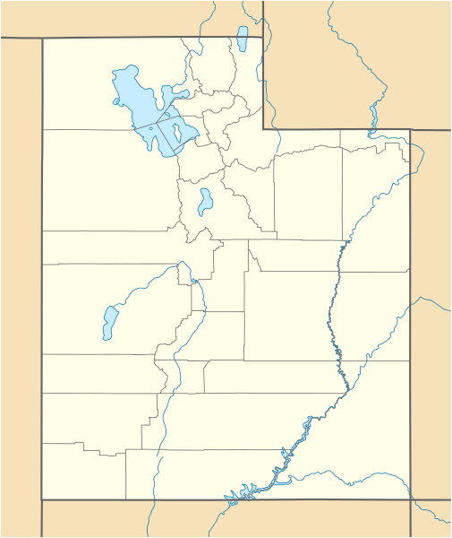
Location map of Utah, USA
Summary[edit]
| Description |
Quadratische Plattkarte, N-S-Streckung 125 %. Geographische Begrenzung der Karte:
Equirectangular projection, N/S stretching 125 %. Geographic limits of the map:
|
| Date | 09-06-2009 |
| Source |
own work, using
|
| Author | NordNordWest |
| Other versions |
Derivative works of this file: |

|
This map has been made or improved in the German Kartenwerkstatt (Map Lab). You can propose maps to improve as well.
|
Licensing[edit]
I, the copyright holder of this work, hereby publish it under the following licenses:

|
Permission is granted to copy, distribute and/or modify this document under the terms of the GNU Free Documentation License, Version 1.2 or any later version published by the Free Software Foundation; with no Invariant Sections, no Front-Cover Texts, and no Back-Cover Texts. A copy of the license is included in the section entitled GNU Free Documentation License. |
This file is licensed under the Creative Commons Attribution 3.0 Unported license.
- You are free:
- to share – to copy, distribute and transmit the work
- to remix – to adapt the work
- Under the following conditions:
- attribution – You must give appropriate credit, provide a link to the license, and indicate if changes were made. You may do so in any reasonable manner, but not in any way that suggests the licensor endorses you or your use.
You may select the license of your choice.
File history
Click on a date/time to view the file as it appeared at that time.
| Date/Time | Thumbnail | Dimensions | User | Comment | |
|---|---|---|---|---|---|
| current | 15:34, 15 June 2015 | | 868 × 1,031 (175 KB) | NordNordWest (talk | contribs) | Reverted to version as of 12:08, 12 December 2010; please upload it as a new file |
| 14:48, 15 June 2015 |  | 868 × 1,031 (289 KB) | Prinsgezinde (talk | contribs) | Reverted to version as of 14:44, 15 June 2015 | |
| 14:47, 15 June 2015 |  | 868 × 1,031 (289 KB) | Prinsgezinde (talk | contribs) | As per revert | |
| 14:44, 15 June 2015 |  | 868 × 1,031 (289 KB) | Prinsgezinde (talk | contribs) | Reverted to version as of 06:39, 12 December 2010 - Unhelpful revert, change was requested and is appreciated | |
| 12:08, 12 December 2010 |  | 868 × 1,031 (175 KB) | NordNordWest (talk | contribs) | no discussion, no change | |
| 06:39, 12 December 2010 |  | 868 × 1,031 (289 KB) | Moabdave (talk | contribs) | Added inset to show location of Utah. Inset derived from File:Map_of_USA_UT.svg. Change made per request at FAC for en:Thistle Utah. | |
| 18:09, 9 June 2009 |  | 868 × 1,031 (175 KB) | NordNordWest (talk | contribs) | {{Information |Description= {{de|Positionskarte von Utah, USA}} Quadratische Plattkarte, N-S-Streckung 125 %. Geographische Begrenzung der Karte: * N: 42.4° N * S: 36.6° N * W: 114.6° W * O: 108.5° W {{en|Location map of [[:en |
You cannot overwrite this file.
File usage on Commons
More than 100 pages use this file. The following list shows the first 100 pages that use this file only. A full list is available.
- Utah
- User:NordNordWest/Gallery/Location maps
- Category:1898 in Utah
- Category:1910 in Utah
- Category:1911 in Utah
- Category:1912 in Utah
- Category:1914 in Utah
- Category:1921 in Utah
- Category:1922 in Utah
- Category:1923 in Utah
- Category:1924 in Utah
- Category:1925 in Utah
- Category:1929 in Utah
- Category:1930 in Utah
- Category:1932 in Utah
- Category:1933 in Utah
- Category:1934 in Utah
- Category:1935 in Utah
- Category:1936 in Utah
- Category:1937 in Utah
- Category:1938 in Utah
- Category:1939 in Utah
- Category:1947 in Utah
- Category:1972 in Utah
- Category:1973 in Utah
- Category:1979 in Utah
- Category:1983 in Utah
- Category:1991 in Utah
- Category:1993 in Utah
- Category:1997 in Utah
- Category:1998 in Utah
- Category:1999 in Utah
- Category:2002 in Utah
- Category:2006 in Utah
- Category:2008 in Utah
- Category:2010 in Utah
- Category:Airports in Utah
- Category:Archaeological sites in Utah
- Category:Bodies of water in Utah
- Category:Bridges in Utah
- Category:Canals in Utah
- Category:Canyons in Utah
- Category:Caves of Utah
- Category:Cemeteries in Utah
- Category:Cities in Utah
- Category:Climate of Utah
- Category:Coal-fired power plants in Utah
- Category:Culture of Utah
- Category:Dams in Utah
- Category:Education in Utah
- Category:Energy in Utah
- Category:Flora of Utah
- Category:Geology of Utah
- Category:Hiking trails in Utah
- Category:Hospitals in Utah
- Category:Islands of Utah
- Category:Lakes of Utah
- Category:Libraries in Utah
- Category:Local government in Utah
- Category:Maps of Utah
- Category:Mountain passes of Utah
- Category:Parks in Utah
- Category:Power plants in Utah
- Category:Protected areas of Utah
- Category:Rail transport in Utah
- Category:Railway bridges in Utah
- Category:Religion in Utah
- Category:Reservoirs in Utah
- Category:Rivers of Utah
- Category:Roads in Utah
- Category:Schools in Utah
- Category:Streets in Utah
- Category:Tabernacles of The Church of Jesus Christ of Latter-day Saints in Utah
- Category:Towers in Utah
- Category:Towns in Utah
- Category:Transport in Utah
- Category:U.S. Highways in Utah
- Category:Utah
- Category:Utah by decade
- Category:Utah in the 1840s
- Category:Utah in the 1890s
- Category:Utah in the 1900s
- Category:Utah in the 1910s
- Category:Utah in the 1920s
- Category:Utah in the 1930s
- Category:Utah in the 1940s
- Category:Utah in the 1950s
- Category:Utah in the 1960s
- Category:Utah in the 1970s
- Category:Utah in the 1980s
- Category:Utah in the 1990s
- Category:Utah in the 19th century
- Category:Utah in the 2000s
- Category:Utah in the 2010s
- Category:Utah in the 20th century
- Category:Utah in the 21st century
- Category:Valleys of Utah
- Category:Visitor attractions in Utah
- Category:Volcanoes in Utah
- Category:Waterfalls in Utah
View more links to this file.
File usage on other wikis
The following other wikis use this file:
- Usage on an.wikipedia.org
- Usage on ar.wikipedia.org
- Usage on ast.wikipedia.org
- Usage on azb.wikipedia.org
- کانیون ریم
- ولف کریک، یوتا
- اقنوق، یوتا
- بالفراق، یوتا
- بریل، یوتا
- داک کریک ویلج، یوتا
- لاپوینت، یوتا
- ماونت کارمل جانکشن، یوتا
- اسکدیل، یوتا
- باربانک، یوتا
- مودنا، یوتا
- لاند، یوتا
- قروور، یوتا
- بلومینقتون، یوتا
- کرویدون، یوتا
- وست وبر، یوتا
- قرینویل، یوتا
- کالاو، یوتا
- آدامزویل، یوتا
- مونتاین هوم، یوتا
- آجاکس، یوتا
- واهساچ، یوتا
- تالمئیج، یوتا
- آلتامونت، یوتا
- وارن، یوتا
- واشاکی، یوتا
- آلتوناه، یوتا
- ترئیس، یوتا
- آلونیت، یوتا
- آمریکان فورک، یوتا
- تیکابو، یوتا
- آپل والئی، یوتا
- ورای، یوتا
- آورورا، یوتا
- آکستل، یوتا
- امیقراشن کانیون، یوتا
- پارک والئی، یوتا
- پارتون، یوتا
- تریدل، یوتا
- تروت کریک، یوتا
- وزت والئی سیتی، یوتا
- پنروز، یوتا
- توکر، یوتا
- پترزون، یوتا
View more global usage of this file.