File:USA Contiguous NoHighschool 2020 Hotspot.jpg
Jump to navigation
Jump to search

Size of this preview: 776 × 600 pixels. Other resolutions: 311 × 240 pixels | 621 × 480 pixels | 994 × 768 pixels | 1,280 × 989 pixels | 2,560 × 1,978 pixels | 5,500 × 4,250 pixels.
Original file (5,500 × 4,250 pixels, file size: 1.93 MB, MIME type: image/jpeg)
Captions
Captions
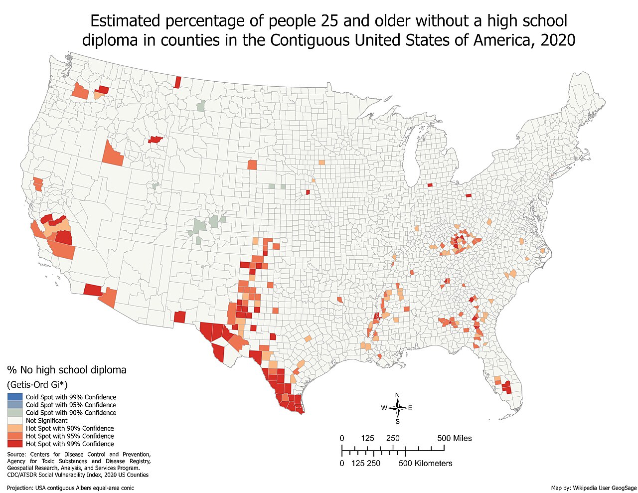
HotSpot map of the estimated percent of people 25 or over without a high school diploma by county in the contiguous United States in 2020
Summary[edit]
| Description |
English: Based on data from the CDC/ATSDR Social Vulnerability Index, this hotspot map shows hot and cold spots estimated percent of people 25 or over without a high school diploma within the Contiguous United States of America. The map was created using the Hotspot Analysis Tool in ArcGIS Pro. Inverse distance squared was used for the Conceptualization of Spatial Relationships.
Source: Centers for Disease Control and Prevention/ Agency for Toxic Substances and Disease Registry/ Geospatial Research, Analysis, and Services Program. CDC/ATSDR Social Vulnerability Index, 2020, Database US Counties https://www.atsdr.cdc.gov/placeandhealth/svi/data_documentation_download.html |
| Date | |
| Source | Own work |
| Author | GeogSage |
Licensing[edit]
I, the copyright holder of this work, hereby publish it under the following license:
This file is licensed under the Creative Commons Attribution 4.0 International license.
- You are free:
- to share – to copy, distribute and transmit the work
- to remix – to adapt the work
- Under the following conditions:
- attribution – You must give appropriate credit, provide a link to the license, and indicate if changes were made. You may do so in any reasonable manner, but not in any way that suggests the licensor endorses you or your use.
File history
Click on a date/time to view the file as it appeared at that time.
| Date/Time | Thumbnail | Dimensions | User | Comment | |
|---|---|---|---|---|---|
| current | 20:19, 10 February 2024 | | 5,500 × 4,250 (1.93 MB) | GeogSage (talk | contribs) | Uploaded own work with UploadWizard |
You cannot overwrite this file.
File usage on Commons
The following page uses this file: