File:USACE Saylorville Lake and Dam.jpg
Jump to navigation
Jump to search

Size of this preview: 800 × 534 pixels. Other resolutions: 320 × 214 pixels | 640 × 427 pixels | 1,024 × 683 pixels | 1,500 × 1,001 pixels.
Original file (1,500 × 1,001 pixels, file size: 341 KB, MIME type: image/jpeg)
Captions
Captions
Add a one-line explanation of what this file represents
| Description |
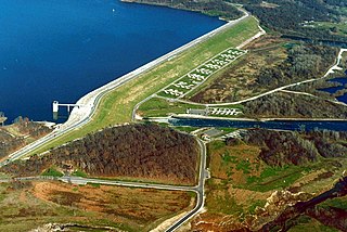
English: Saylorville Dam, impounding Saylorville Lake, also known as Saylorville Reservoir. The dam is located on the Des Moines River, 11 miles upriver of Des Moines, Iowa, USA. The U.S. Army Corps of Engineers constructed the dam for flood control on the Des Moines river and the Mississippi River, of which the Des Moines River is a tributary. The dam was completed in 1977. |
|||
| Date | not specified or unknown | |||
| Source |
U.S. Army Corps of Engineers Digital Visual Library Image page Image description page Digital Visual Library home page |
|||
| Author | U.S. Army Corps of Engineers, photographer not specified or unknown | |||
| Permission (Reusing this file) |
|
| Camera location | | View this and other nearby images on: OpenStreetMap |
|---|
File history
Click on a date/time to view the file as it appeared at that time.
| Date/Time | Thumbnail | Dimensions | User | Comment | |
|---|---|---|---|---|---|
| current | 00:07, 3 April 2007 | | 1,500 × 1,001 (341 KB) | DanMS (talk | contribs) | {{Information | Description = {{en|Saylorville Dam, impounding Saylorville Lake, also known as Saylorville Reservoir. The dam is located on the Des Moines River, 11 miles upriver of Des Moines, Iowa, USA. The U.S. Army Corps of Engineers constructed th |
You cannot overwrite this file.
File usage on Commons
There are no pages that use this file.
File usage on other wikis
The following other wikis use this file:
- Usage on en.wikipedia.org
- Usage on es.wikipedia.org