File:USACE Howell Heflin Lock and Dam.jpg
Jump to navigation
Jump to search

Size of this preview: 800 × 558 pixels. Other resolutions: 320 × 223 pixels | 640 × 447 pixels | 1,024 × 715 pixels | 1,280 × 893 pixels | 1,500 × 1,047 pixels.
Original file (1,500 × 1,047 pixels, file size: 274 KB, MIME type: image/jpeg)
Captions
Captions
Add a one-line explanation of what this file represents
| Description |
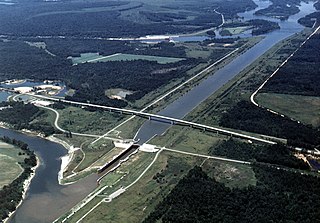
English: Aerial view of Howell Heflin Lock and Dam on the Tombigbee River, which is a part of the Tennessee-Tombigbee Waterway. The lock is located on a straightened and channelized section of the Waterway which bypasses a loop in the river. The associated dam (visible at top center) is actually located nearly two miles away on the original meandering path of the river. The lock and dam are part of the Tennessee-Tombigbee project, constructed by the U.S. Army Corps of Engineers for barge navigation from the Tennessee River to the Gulf of Mexico. The lock is located in Greene County, Alabama, near the town of Gainesville. The river here is the border between Greene County and Sumter County, and the dam spans the border between the two counties. Howell Heflin Lock is the lowest (farthest downriver) lock on the Tennessee-Tombigbee Waterway. View is upriver to the northwest.
Coordinates: 32°50′12.86″N 88°8′8.73″W / 32.8369056°N 88.1357583°W |
|||
| Location | Greene and Sumter Counties, Alabama, USA | |||
| Date | (Caveat: Dates provided by U.S. Army Corps of Engineers Digital Visual Library are not reliable and may be wrong.) | |||
| Source |
U.S. Army Corps of Engineers Digital Visual Library Image page Image description page Digital Visual Library home page |
|||
| Author | Adrien Lamarre, U.S. Army Corps of Engineers | |||
| Permission (Reusing this file) |
|
File history
Click on a date/time to view the file as it appeared at that time.
| Date/Time | Thumbnail | Dimensions | User | Comment | |
|---|---|---|---|---|---|
| current | 19:27, 29 April 2007 | | 1,500 × 1,047 (274 KB) | DanMS (talk | contribs) | {{Information | Description = {{en|Aerial view of Howell Heflin Lock and Dam on the Tombigbee River, which is a part of the Tennessee-Tombigbee Waterway. The lock is located on a straightened and channelized section of the Waterway which bypasses a loo |
You cannot overwrite this file.
File usage on Commons
There are no pages that use this file.
File usage on other wikis
The following other wikis use this file:
- Usage on el.wikipedia.org
- Usage on en.wikipedia.org
- Usage on hu.wikipedia.org
- Usage on ja.wikipedia.org
- Usage on ro.wikipedia.org
- Usage on www.wikidata.org