File:U-Map Vienna U5.svg
Jump to navigation
Jump to search

Size of this PNG preview of this SVG file: 667 × 600 pixels. Other resolutions: 267 × 240 pixels | 534 × 480 pixels | 854 × 768 pixels | 1,139 × 1,024 pixels | 2,278 × 2,048 pixels | 2,176 × 1,956 pixels.
Original file (SVG file, nominally 2,176 × 1,956 pixels, file size: 6.69 MB)
Captions
Captions
Add a one-line explanation of what this file represents
Summary[edit]
| Description |
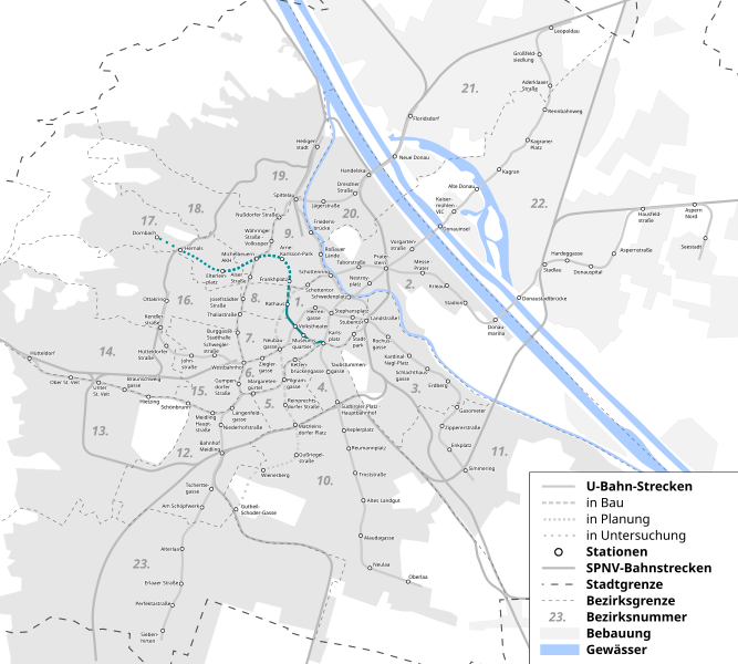
Deutsch: Durchgehende U-Bahn-Linien sind nach Ausbaustufe 4, gestrichelte nach der Ausbaustufe 5 |
| Date | |
| Source | Own work auf Grundlage der OpenStreetMap © OpenStreetMap-Mitwirkende |
| Author | Gnlpfth12 |
Licensing[edit]
I, the copyright holder of this work, hereby publish it under the following license:
This file is licensed under the Creative Commons Attribution-Share Alike 4.0 International license.
- You are free:
- to share – to copy, distribute and transmit the work
- to remix – to adapt the work
- Under the following conditions:
- attribution – You must give appropriate credit, provide a link to the license, and indicate if changes were made. You may do so in any reasonable manner, but not in any way that suggests the licensor endorses you or your use.
- share alike – If you remix, transform, or build upon the material, you must distribute your contributions under the same or compatible license as the original.
File history
Click on a date/time to view the file as it appeared at that time.
| Date/Time | Thumbnail | Dimensions | User | Comment | |
|---|---|---|---|---|---|
| current | 17:54, 5 November 2021 | | 2,176 × 1,956 (6.69 MB) | Gnlpfth12 (talk | contribs) | +Hintergrund |
| 17:52, 5 November 2021 |  | 2,176 × 1,956 (6.69 MB) | Gnlpfth12 (talk | contribs) | An Status Quo angepasst, falsche Linienwegsänderungen revertiert | |
| 18:13, 4 November 2021 |  | 2,176 × 1,956 (6.67 MB) | Kematen (talk | contribs) | kleine Änderung | |
| 17:55, 4 November 2021 |  | 2,176 × 1,956 (6.67 MB) | Kematen (talk | contribs) | Hernals ist fix | |
| 14:09, 4 September 2021 |  | 2,176 × 1,956 (6.69 MB) | Gnlpfth12 (talk | contribs) | renewed (new data source) | |
| 10:50, 11 August 2021 |  | 2,176 × 1,956 (3.67 MB) | Kematen (talk | contribs) | Fehler ausgebessert | |
| 07:44, 4 August 2021 |  | 2,176 × 1,956 (3.68 MB) | Gnlpfth12 (talk | contribs) | neue Linienfarbe, +Bebauung und Bezirke | |
| 21:33, 3 August 2021 |  | 2,106 × 1,885 (1.04 MB) | Kematen (talk | contribs) | Die fünfte Ausbaustufe ist in Planung. Also der Plan der Wr. Linien ist bis Hernals zu bauen. Strecke Frankhplatz - Elterleinplatz ist auch nicht "fix". | |
| 07:44, 2 August 2021 |  | 2,106 × 1,885 (1.03 MB) | Gnlpfth12 (talk | contribs) | Reverted to version as of 20:45, 11 March 2021 (UTC): analog zum Artikel. Begründung ist exakt dieselbe: "keine E-Mails schreiben, warten bis es offizielle Veröffentlichugen gibt" | |
| 17:46, 29 July 2021 |  | 2,106 × 1,885 (1.04 MB) | Kematen (talk | contribs) | Reverted to version as of 15:26, 29 July 2021 (UTC) Bitte stoppe das Edit-Warring. Die Karte stimmt. Ich habe sogar wegen dir den Wr. Linien geschrieben und die haben es gesagt, dass sie eine zweite Verlängerung über Arne-Karlsson-Park, Michelbeuern, Elterleinplatz nach Hernals planen. |
You cannot overwrite this file.
File usage on Commons
The following 9 pages use this file:
- User:Chumwa/OgreBot/Public transport information/2020 February 20-29
- User:Chumwa/OgreBot/Public transport information/2021 March 11-20
- User:Chumwa/OgreBot/Public transport information/2021 November 1-10
- User:Chumwa/OgreBot/Public transport information/2021 September 1-10
- User:Chumwa/OgreBot/Transport Maps/2020 February 20-29
- User:Chumwa/OgreBot/Transport Maps/2021 March 11-20
- User:Chumwa/OgreBot/Transport Maps/2021 November 1-10
- User:Chumwa/OgreBot/Transport Maps/2021 September 1-10
- Category:Metro line U5 (Vienna)
File usage on other wikis
The following other wikis use this file:
- Usage on de.wikipedia.org
- Usage on it.wikipedia.org
- Usage on www.wikidata.org