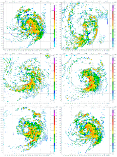
File:Typhoon Mawar 2005 computer simulation thumbnail.gif
Typhoon_Mawar_2005_computer_simulation_thumbnail.gif (450 × 403 pixels, file size: 869 KB, MIME type: image/gif, looped, 49 frames, 5.3 s)
Captions
Captions
| DescriptionTyphoon Mawar 2005 computer simulation thumbnail.gif | A 48 hour simulation of Typhoon Mawar using the Weather Research and Forecasting model. At this time, Mawar was at approximately 24N 140E and moving slowly to the north. Initial conditions and boundary conditions are from the 1 degree FNL reanalysis (approximately 110 kilometers, 68 miles). The simulation runs from 22 August 2005 00:00 Zulu to 24 August 2005 00:00 Zulu. The model has 3.3 kilometre (2.1 mile) grid point spacing, and utilizes vortex following which is why the typhoon remains in the middle of the frame. Approximately the first 24 hours (frames) show the model "spinning up"— which is the amount of time needed for the model physics to reach equilibrium with the applied boundary conditions. After the initial round of convection in the first couple frames, gravity waves can be seen propagating outward from the center of convection, especially in the northwest quadrant of the storm system. The final 24 hours (frames) represent a high resolution simulation of the actual typhoon. The reds and oranges represent high rainfall rates, blues and greens light rainfall, and the white are regions of no rainfall. |
| Date | (UTC) |
| Source | |
| Author |
|
| This is a retouched picture, which means that it has been digitally altered from its original version. Modifications: create thumbnail. The original can be viewed here: Typhoon Mawar 2005 computer simulation.gif:
|
- You are free:
- to share – to copy, distribute and transmit the work
- to remix – to adapt the work
- Under the following conditions:
- attribution – You must give appropriate credit, provide a link to the license, and indicate if changes were made. You may do so in any reasonable manner, but not in any way that suggests the licensor endorses you or your use.
- share alike – If you remix, transform, or build upon the material, you must distribute your contributions under the same or compatible license as the original.
Original upload log[edit]
This image is a derivative work of the following images:
- File:Typhoon_Mawar_2005_computer_simulation.gif licensed with Cc-by-sa-3.0
- 2010-07-01T15:52:43Z Atmoz 1380x1235 (4622294 Bytes) fix transparency "issue"
- 2010-07-01T15:48:49Z Atmoz 1380x1235 (4627300 Bytes) last frame first
- 2010-07-01T05:59:02Z Atmoz 1380x1235 (4655873 Bytes) {{Information |Description=A 48 hour simulation of [[w:Typhoon Mawar|Typhoon Mawar]] using the [[w:Weather Research and Forecasting model|Weather Research and Forecasting model]]. Initial conditions and boundary conditions ar
Uploaded with derivativeFX
File history
Click on a date/time to view the file as it appeared at that time.
| Date/Time | Thumbnail | Dimensions | User | Comment | |
|---|---|---|---|---|---|
| current | 15:59, 1 July 2010 |  | 450 × 403 (869 KB) | Atmoz (talk | contribs) | {{Information |Description=A 48 hour simulation of Typhoon Mawar using the Weather Research and Forecasting model. Initial conditions and boundary conditions are 1 degree reanalysis. |Source |
You cannot overwrite this file.
File usage on Commons
The following page uses this file:
File usage on other wikis
The following other wikis use this file:
- Usage on ar.wikipedia.org
- Usage on bg.wikipedia.org
- Usage on ca.wikipedia.org
- Usage on cs.wikipedia.org
- Usage on en.wikipedia.org
- Usage on es.wikipedia.org
- Usage on fr.wikipedia.org
- Usage on hi.wikipedia.org
- Usage on hu.wikipedia.org
- Usage on id.wikipedia.org
- Usage on io.wikipedia.org
- Usage on ja.wikipedia.org
- Usage on kk.wikipedia.org
- Usage on la.wikipedia.org
- Usage on ms.wikipedia.org
- Usage on pl.wikipedia.org
- Usage on ru.wikipedia.org
- Usage on sk.wikipedia.org
- Usage on sr.wikipedia.org
- Usage on uk.wikipedia.org
- Usage on www.wikidata.org
- Usage on zh-yue.wikipedia.org
- Usage on zh.wikipedia.org
- Usage on zu.wikipedia.org
Metadata
This file contains additional information such as Exif metadata which may have been added by the digital camera, scanner, or software program used to create or digitize it. If the file has been modified from its original state, some details such as the timestamp may not fully reflect those of the original file. The timestamp is only as accurate as the clock in the camera, and it may be completely wrong.
| GIF file comment | Created with The GIMP |
|---|
