File:Typhoon Haiyan 16 oct 2001 0245Z.jpg
Jump to navigation
Jump to search

Size of this preview: 461 × 599 pixels. Other resolutions: 184 × 240 pixels | 369 × 480 pixels | 591 × 768 pixels | 788 × 1,024 pixels | 1,575 × 2,048 pixels | 8,000 × 10,400 pixels.
Original file (8,000 × 10,400 pixels, file size: 10.28 MB, MIME type: image/jpeg)
Captions
Captions
Add a one-line explanation of what this file represents
| Warning | The original file is very high-resolution. It might not load properly or could cause your browser to freeze when opened at full size. |
|---|
Summary[edit]
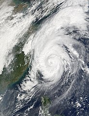
| Description | In the northwest Pacific Ocean, Typhoon Haiyan was downgraded to a tropical storm as of October 17, 2001. This Moderate-resolution Imaging Spectroradiometer (MODIS) image from October 16 shows Haiyan while it was still a typhoon, covering the Ryukyu Islands, which run in an arc between Taiwan (left of center) and Japan (upper right). The storm moved east-northeast, and was predicted to weaken as it moved out of warmer waters. | |||||
| Date | ||||||
| Source | http://visibleearth.nasa.gov/view_rec.php?id=2176 | |||||
| Author | Jacques Descloitres, MODIS Land Rapid Response Team, NASA/GSFC | |||||
| Permission (Reusing this file) |
|

File history
Click on a date/time to view the file as it appeared at that time.
| Date/Time | Thumbnail | Dimensions | User | Comment | |
|---|---|---|---|---|---|
| current | 20:36, 3 December 2006 | | 8,000 × 10,400 (10.28 MB) | Good kitty (talk | contribs) | == Summary == {{Information |Description=In the northwest Pacific Ocean, Typhoon Haiyan was downgraded to a tropical storm as of October 17, 2001. This Moderate-resolution Imaging Spectroradiometer (MODIS) image from October 16 shows Haiyan while it was s |
You cannot overwrite this file.
File usage on Commons
The following page uses this file:
File usage on other wikis
The following other wikis use this file:
- Usage on en.wikipedia.org
- Usage on ja.wikipedia.org
- Usage on ko.wikipedia.org
- Usage on th.wikipedia.org
- Usage on vi.wikipedia.org
- Usage on zh.wikipedia.org