File:Typhoon Goni, Philippines.png

Original file (3,507 × 2,480 pixels, file size: 11.74 MB, MIME type: image/png)
Captions
Captions
Summary[edit]
| Description |
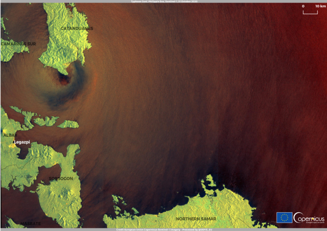
English: Typhoon Goni, Asia's most powerful typhoon this year, has made landfall in the Philippines with maximum sustained winds of 225km/h (140mph). The state weather service said the typhoon hit Catanduanes island on Sunday at 04:50 local time (19:50 GMT Saturday). It has since crossed onto the main island of Luzon, where the capital Manila is located. Almost a million people have been evacuated from their homes. Catastrophic winds and intense to torrential rainfall are forecasted according to weather and disaster management officials. The storm is expected to cross over Luzon south of Manila and continue into the South China Sea on Sunday afternoon. Goni - known as Rolly in the Philippines - is the most powerful storm to hit the Philippines since Typhoon Haiyan killed more than 6,000 people in 2013. This image is a false colour combination of radar images captured by one of the two Copernicus Sentinel-1 satellites on 31 October 2020 at 21:30 UTC. It shows the eye of the typhoon while making landfall in the island of Catanduanes. The Copernicus Sentinel-1 mission is composed of two twin satellites (Sentinel-1A and Sentinel-1B) which are equipped with a Synthetic Aperture Radar (SAR) that provide continuous all-weather, day-and-night imagery for multiple applications. In particular, new techniques have been developed allowing the radar to measure sea-surface wind and wave heights. This information about the sea state can help to assess how destructive hurricanes and typhoons are and predict their path – and, therefore, where and when they are likely to make landfall.The same data can also be used to alert ships and to issue warnings for coastal flooding. |
| Date | Taken on 31 October 2020 |
| Source | Typhoon Goni, Philippines |
| Author | European Union , Copernicus Sentinel-1 imagery |
Licensing[edit]

|
This image contains data from a satellite in the Copernicus Programme, such as Sentinel-1, Sentinel-2 or Sentinel-3. Attribution is required when using this image.
Attribution: Contains modified Copernicus Sentinel data 2020
The use of Copernicus Sentinel Data is regulated under EU law (Commission Delegated Regulation (EU) No 1159/2013 and Regulation (EU) No 377/2014). Relevant excerpts:
Free access shall be given to GMES dedicated data [...] made available through GMES dissemination platforms [...].
Access to GMES dedicated data [...] shall be given for the purpose of the following use in so far as it is lawful:
GMES dedicated data [...] may be used worldwide without limitations in time.
GMES dedicated data and GMES service information are provided to users without any express or implied warranty, including as regards quality and suitability for any purpose. |
File history
Click on a date/time to view the file as it appeared at that time.
| Date/Time | Thumbnail | Dimensions | User | Comment | |
|---|---|---|---|---|---|
| current | 08:10, 24 August 2023 | | 3,507 × 2,480 (11.74 MB) | OptimusPrimeBot (talk | contribs) | #Spacemedia - Upload of https://www.copernicus.eu/system/files/2020-11/image_day/TyphoonGoni.png via Commons:Spacemedia |
You cannot overwrite this file.
File usage on Commons
There are no pages that use this file.