File:Turkish Airlines Flight 1951 crash location near Schiphol Polderbahn.png
Jump to navigation
Jump to search

Size of this preview: 256 × 598 pixels. Other resolutions: 102 × 240 pixels | 358 × 836 pixels.
Original file (358 × 836 pixels, file size: 91 KB, MIME type: image/png)
Captions
Captions
Add a one-line explanation of what this file represents
Summary[edit]
| Description |
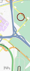
English: Turkish Airlines Flight 1951 crash location near Schiphol Polderbaan runway.
Approximate coordinates of circle: lat=52.377716, lon=4.711976. Nederlands: Locatie van de crash van Turkish Airlines-vlucht 1951 bij de Polderbaan van Schiphol.
Geschatte coördinaten van cirkel: lat=52.377716, lon=4.711976. |
| Date | |
| Source |
|
| Author | edited by 84user |
See also[edit]

Licensing[edit]
This file is licensed under the Creative Commons Attribution-Share Alike 2.0 Generic license.
- You are free:
- to share – to copy, distribute and transmit the work
- to remix – to adapt the work
- Under the following conditions:
- attribution – You must give appropriate credit, provide a link to the license, and indicate if changes were made. You may do so in any reasonable manner, but not in any way that suggests the licensor endorses you or your use.
- share alike – If you remix, transform, or build upon the material, you must distribute your contributions under the same or compatible license as the original.
File history
Click on a date/time to view the file as it appeared at that time.
| Date/Time | Thumbnail | Dimensions | User | Comment | |
|---|---|---|---|---|---|
| current | 21:23, 25 February 2009 | | 358 × 836 (91 KB) | 84user (talk | contribs) | == Summary == {{Information |Description=Turkish Airlines Flight 1951 crash location near Schiphol Polderbahn runway. Approximate coordinates of circle: lat=52.377716, lon=4.711976. |Source=*Map based on the free editable OSM map http://www.openstreetmap. |
You cannot overwrite this file.
File usage on Commons
The following page uses this file: