File:Turkeli.png
Original file (976 × 574 pixels, file size: 61 KB, MIME type: image/png)
Captions
Captions

|
This file, which was originally posted to an external website, has not yet been reviewed by an administrator or reviewer to confirm that the above license is valid. See Category:License review needed for further instructions.
|
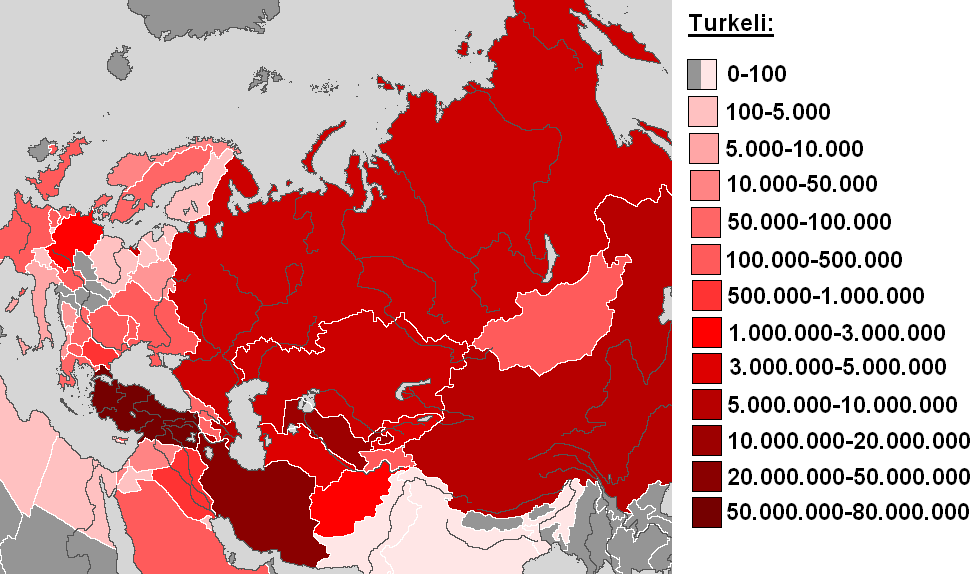
Türkçe:
Aslen bu harita haritayla temellendirilmedi "Turkeli.jpg." Türk halkalari dağıtımı şimdi tek hükümetlere işaretler. Bu çizme toplum alan çekilen dahi yazarın yan ve Lisans "GÖBL-Kişisel" bu ilanla var!
English:
Originally this map was based on the map "Turkeli.jpg". and the distribution of the Turkic peoples points at the individual states now. This map the "Public domain" was drawn even by the author and has with this publication the License status "Public domain"!
Deutsch:
Diese Landkarte basierte ursprünglich auf dem Bild "Turkeli.jpg." und zeigt nun die Verbreitung der türkischen Völker auf die einzelnen Staaten. Diese Landkarte wurde selbst durch den Autor gezeichnet und verfügt mit dieser Veröffentlichung über den Lizenzstatus des "Public domain"!
Licensing[edit]

|
Permission is granted to copy, distribute and/or modify this document under the terms of the GNU Free Documentation License, Version 1.2 or any later version published by the Free Software Foundation; with no Invariant Sections, no Front-Cover Texts, and no Back-Cover Texts. A copy of the license is included in the section entitled GNU Free Documentation License. |
If this file is eligible for relicensing, it may also be used under the Creative Commons Attribution-ShareAlike 3.0 license. The relicensing status of this image has not yet been reviewed. You can help.
|
| This work has been released into the public domain by its author, Postmann Michael at English Wikipedia. This applies worldwide. In some countries this may not be legally possible; if so: Postmann Michael grants anyone the right to use this work for any purpose, without any conditions, unless such conditions are required by law. |
File history
Click on a date/time to view the file as it appeared at that time.
| Date/Time | Thumbnail | Dimensions | User | Comment | |
|---|---|---|---|---|---|
| current | 04:20, 19 November 2006 | | 976 × 574 (61 KB) | Postmann Michael~trwiki (talk | contribs) | Ili-Fluß leicht überarbeitet |
| 23:20, 6 November 2006 |  | 976 × 574 (61 KB) | Postmann Michael~trwiki (talk | contribs) | Auf eine alte Version zurückgesetzt | |
| 23:11, 6 November 2006 |  | 672 × 574 (59 KB) | Postmann Michael~trwiki (talk | contribs) | revised and adapted to colors | |
| 23:07, 6 November 2006 |  | 672 × 574 (59 KB) | Postmann Michael~trwiki (talk | contribs) | revise. inadvertently wrong version loaded. Letzer test. I always see only this an old map! | |
| 23:03, 6 November 2006 |  | 672 × 574 (59 KB) | Postmann Michael~trwiki (talk | contribs) | revise. inadvertently wrong version loaded | |
| 17:46, 4 November 2006 |  | 976 × 574 (61 KB) | Postmann Michael~trwiki (talk | contribs) | Originally this map was based on the map "Turkeli.jpg". and the distribution of the Turkic peoples points at the individual states now. This map the "Public domain" was drawn even by the author and has with this publication the Lizensstatus! Diese Landka |
You cannot overwrite this file.
File usage on Commons
The following page uses this file:
File usage on other wikis
The following other wikis use this file:
- Usage on tr.wikipedia.org