File:Turkeli.A.png
Turkeli.A.png (672 × 574 pixels, file size: 59 KB, MIME type: image/png)
Captions
Captions

|
This file, which was originally posted to an external website, has not yet been reviewed by an administrator or reviewer to confirm that the above license is valid. See Category:License review needed for further instructions.
|
Revision of the map "Turkeli.jpg"
Türkçe
Notlar:
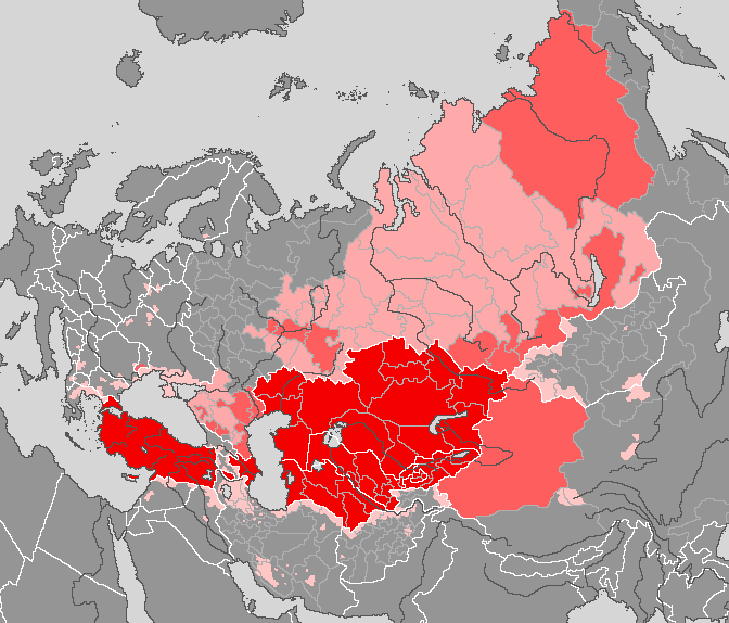
Bu harita Türki halkların dağılımını göstermektedir. Ülkeler kırmızı, otonom cumhuriyetler ve bölgeler koyu pembedir. Moğolistan ve Rusya'da bulunan, içinde büyük bir Türki azınlık olan idari birimler ise pembedir. Otonom olmayan bölgeler, örneğin İran'ın göçebe bölgeleri ve Balkanlardaki Türk yerleşim alanları, açık pembedir.
Genel bir görüntü sunmak amacıyla hazırlanmış bu harita tüm ayrıntıları ile doğru değidir.
(Eksikler ve hatalar yakın gelecekte düzeltilecektir!)
English
Notes:
This map represents the area of distribution of the Turkic peoples. Independent states are kept to a red and autonomous republics and areas into brighter red something. Those administrative units of Russia and in which a strong Turkic minority represent, like Mongolia, held in the color pink. Areas without autonomy, like the nomad areas of Iran or the Turkish settlement areas on the Balkans, are kept in a pale pink.
This map doesn't lay the claim to be 100% exact. This map wants to give only an overview.
(The map will be edited also in future!)
Deutsch
Bemerkungen:
Diese Karte zeigt das Verbreitungsgebiet der türkischen Völker. Unabhängige Staaten werden in Rot und Autonome Republiken und Gebiete in einem helleren Rot dargestellt. In den Verwaltungseinheiten Rußlands und in Gebieten wie der Mongolei, in denen eine starke türkische Minderheit vorherrscht, sind in diese in Rosa dargestellt. In Gebieten ohne Autonomiestatus, wie die Nomadengebieten im Iran oder die türksischen Siedlungsgebiete auf dem Balkan, wird die Farbe Blaß-Rosa verwendet.
Diese Karte erhebt nicht den Anspruch der 100%igen Genauigkeit. Diese Karte will nur einen Überblick geben.
(Diese Karte wird regelmäßig bearbeitet!)

|
Permission is granted to copy, distribute and/or modify this document under the terms of the GNU Free Documentation License, Version 1.2 or any later version published by the Free Software Foundation; with no Invariant Sections, no Front-Cover Texts, and no Back-Cover Texts. A copy of the license is included in the section entitled GNU Free Documentation License. |
If this file is eligible for relicensing, it may also be used under the Creative Commons Attribution-ShareAlike 3.0 license. The relicensing status of this image has not yet been reviewed. You can help.
|
| This work has been released into the public domain by its author, Postmann Michael at English Wikipedia. This applies worldwide. In some countries this may not be legally possible; if so: Postmann Michael grants anyone the right to use this work for any purpose, without any conditions, unless such conditions are required by law. |
File history
Click on a date/time to view the file as it appeared at that time.
| Date/Time | Thumbnail | Dimensions | User | Comment | |
|---|---|---|---|---|---|
| current | 04:29, 19 November 2006 | | 672 × 574 (59 KB) | Postmann Michael~trwiki (talk | contribs) | weitere Streusiedlungen eingefügt |
| 22:33, 9 November 2006 |  | 672 × 574 (59 KB) | Postmann Michael~trwiki (talk | contribs) | little changes | |
| 23:22, 6 November 2006 |  | 672 × 574 (59 KB) | Postmann Michael~trwiki (talk | contribs) | revise | |
| 22:58, 6 November 2006 |  | 672 × 574 (59 KB) | Postmann Michael~trwiki (talk | contribs) | revise | |
| 00:15, 5 November 2006 |  | 672 × 574 (59 KB) | Postmann Michael~trwiki (talk | contribs) | Revision of the map "Turkeli.jpg" |
You cannot overwrite this file.
File usage on Commons
There are no pages that use this file.
File usage on other wikis
The following other wikis use this file: