File:Tstorms5m3a1245z-2332z.gif
Jump to navigation
Jump to search
No higher resolution available.
Tstorms5m3a1245z-2332z.gif (432 × 311 pixels, file size: 5.19 MB, MIME type: image/gif, looped, 50 frames, 4.0 s)
Captions
Captions
Add a one-line explanation of what this file represents
Summary[edit]
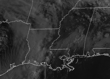
| Description | A satellite loop of strong thunderstorms over Texas and Lousiana on May 3, 2007. |
| Date | May 3(1245Z)-3(2332Z), 2007 |
| Source | http://rsd.gsfc.nasa.gov/goes/ |
| Author | NASA-GSFC, data from NOAA GOES |
Licensing[edit]
This image is in the public domain because it contains materials that originally came from the U.S. National Oceanic and Atmospheric Administration, taken or made as part of an employee's official duties.
|
File history
Click on a date/time to view the file as it appeared at that time.
| Date/Time | Thumbnail | Dimensions | User | Comment | |
|---|---|---|---|---|---|
| current | 00:28, 4 May 2007 | | 432 × 311 (5.19 MB) | Clamity21 (talk | contribs) | {{Information |Description=A satellite loop of strong thunderstorms over Texas and Lousiana on May 3, 2007. |Source=http://rsd.gsfc.nasa.gov/goes/ |Date=May 3(1245Z)-3(2332Z), 2007 |Author=NASA-GSFC, data from NOAA GOES |Permission= |other_versions= }} |
You cannot overwrite this file.
File usage on Commons
There are no pages that use this file.