File:Tropical Storm Cempaka off of China (MODIS 2021-07-20).jpg

Original file (5,426 × 4,548 pixels, file size: 2.25 MB, MIME type: image/jpeg)
Captions
Captions
Summary
[edit].jpg&action=edit§ion=1)
| Description |
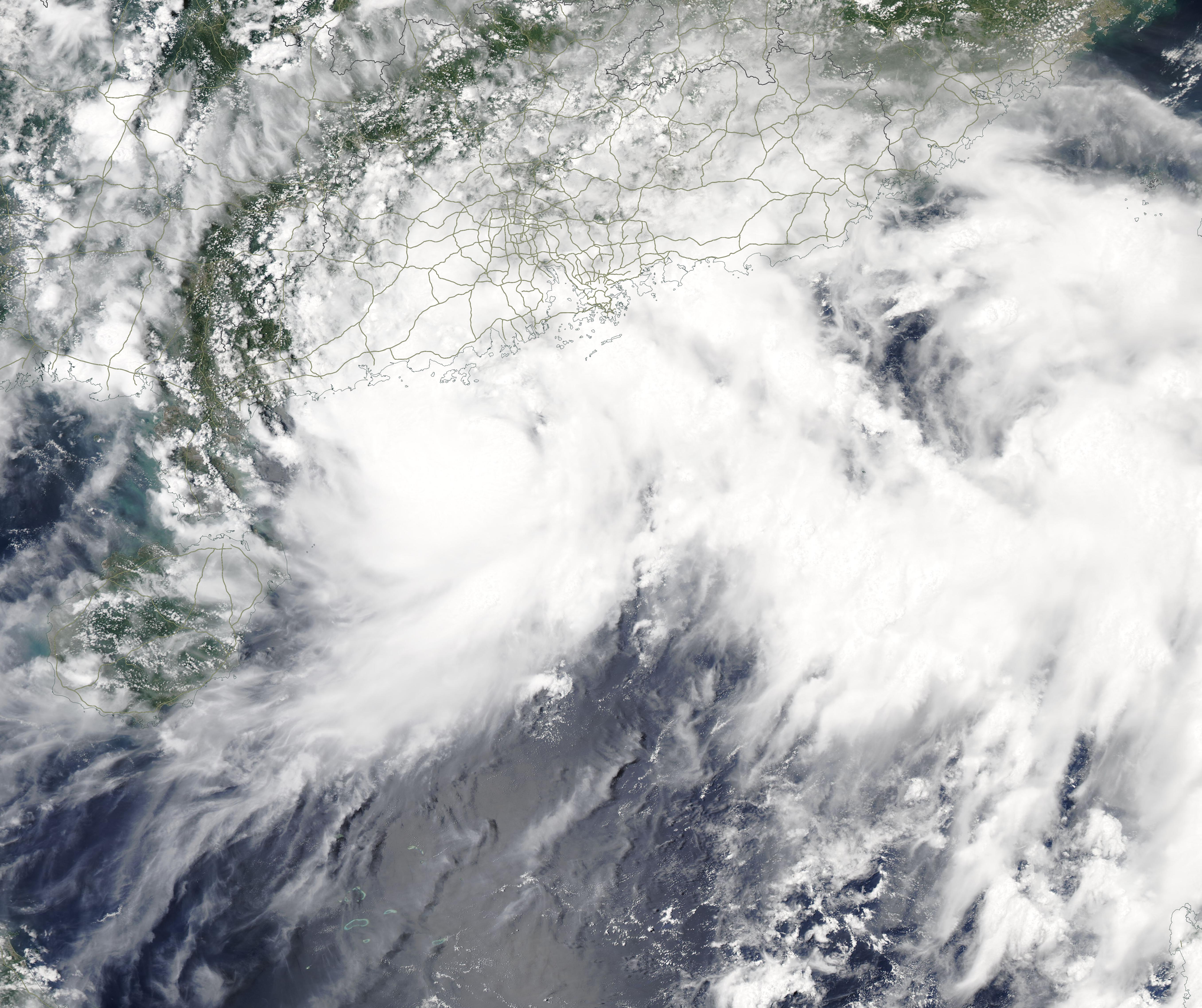
English: Tropical Storm Cempaka formed over the South China Sea about 145 km (90 miles) south-east of Yangjiang City, Guangdong Province, China on July 18, 2021. It slowly strengthened through the day, with maximum sustained winds reaching 50 mph (81 km/h). By the afternoon of July 19, Cempaka became a typhoon as it took aim at coastal Guangdong Province.
At 11:00 p.m. EDT on July 19 (0300 UTC on July 20), the Joint Typhoon Warning Center (JTWC) reported that Typhoon Cempaka carried maximum sustained winds of 75 mph (121 km/h), which placed it at Category 1 strength on the Saffir-Simpson Hurricane Wind Scale. The storm was located approximately 135 miles (217 km) west-southwest of Hong Kong and was tracking northwestward. Maximum significant wave height was 24 feet. Typhoon Cempaka is expected to continue to track northwestward and make landfall on July 20 along the southeastern coast of China near Yangjiang. After landfall, the JTWC forecasts that the storm will begin to make a tight left U-turn tracing the west coast of the Leizhou Peninsula into the eastern tip of Hainan before exiting back into the South China Sea. Interaction with the rugged interior of China is expected to rapidly decay Typhoon Cempaka, dropping wind speeds to 34 mph (55 km/h). However, the storm will bring heavy rain to much of southeastern China over several days. The Moderate Resolution Imaging Spectroradiometer (MODIS) on board NASA’s Aqua satellite acquired a true-color image of Cempaka on July 19 when it was still at tropical storm strength. The intensifying storm appears somewhat disorganized, but a cloud-filled center of circulation can be seen south of the China coastline while convective bands hang over the coast. |
||
| Date | Taken on 19 July 2021 | ||
| Source |
Tropical Storm Cempaka off of China (direct link)
|
||
| Author | MODIS Land Rapid Response Team, NASA GSFC |
| This media is a product of the Aqua mission Credit and attribution belongs to the mission team, if not already specified in the "author" row |
Licensing
[edit].jpg&action=edit§ion=2)
| This file is in the public domain in the United States because it was solely created by NASA. NASA copyright policy states that "NASA material is not protected by copyright unless noted". (See Template:PD-USGov, NASA copyright policy page or JPL Image Use Policy.) | ||
 |
Warnings:
|
File history
Click on a date/time to view the file as it appeared at that time.
| Date/Time | Thumbnail | Dimensions | User | Comment | |
|---|---|---|---|---|---|
| current | 17:38, 30 January 2024 | | 5,426 × 4,548 (2.25 MB) | OptimusPrimeBot (talk | contribs) | #Spacemedia - Upload of http://modis.gsfc.nasa.gov/gallery/images/image07202021_250m.jpg via Commons:Spacemedia |
You cannot overwrite this file.
File usage on Commons
There are no pages that use this file.
.jpg&oldid=847421312)