File:Trojmezí Kremenec.jpg
Jump to navigation
Jump to search

Size of this preview: 800 × 600 pixels. Other resolutions: 320 × 240 pixels | 640 × 480 pixels | 1,024 × 768 pixels | 1,280 × 960 pixels | 2,560 × 1,920 pixels | 3,072 × 2,304 pixels.
Original file (3,072 × 2,304 pixels, file size: 3.26 MB, MIME type: image/jpeg)
Captions
Captions
Add a one-line explanation of what this file represents
| Description |
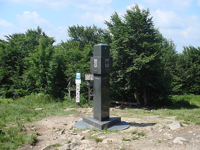
Čeština: Slovensko-polsko-ukrajinské trojmezí Kremenec/Krzemieniec/Кременець, nejvýchodnější bod Slovenska a bývalý nejvýchodnější bod Československa po připojení Podkarpatské Rusi k Sovětskému svazu v roce 1945 (pohled z polsko-ukrajinské hranice).
English: Slovak, Polish and Ukrainian border tripoint Kremenec/Krzemieniec/Кременець, the most eastern point of Slovakia and the former most eastern point of Czechoslovakia after the annexation of the Subcarpathian Ruthenia by the Soviet Union in 1945 (view from the Polish-Ukrainian border).
Français : Le tripoint de la Pologne, la Slovaquie et l'Ukraine Krzemieniec/Kremenec/Кременець, le point le plus est de la Slovaquie et au passé le point le plus est de la Tchécoslovaquie àpres annexation de la Ruthénie subcarpathique à l'Union soviétique au 1945 (vue de la frontière entre la Pologne et l'Ukraine).
Polski: Polsko-ukraińsko-słowacki trójstyk Krzemieniec/Кременець/Kremenec (widok z granicy polsko-ukraińskej).
Русский: Стык границ Украины, Польши и Словакии Кременець/Krzemieniec/Kremenec, самая восточная точка Словакии и бывшая самая восточная точка Чехословакии после присоедения Подкарпатской Руси к Советскому Союзу в 1945 году (вид из украинско-польской границы).
Українська: Потрійний стик кордонів Словаччини, Польщі та України Kremenec/Krzemieniec/Кременець, найсхідніша точка Словаччини та колишня найсхідніша точка Чехословаччини після приєднання Підкарпатської Русі до Радянського Союзу (вигляд із польсько-українського кордону). |
||||||||
| Date | |||||||||
| Source | Own work | ||||||||
| Author | Ondřej Žváček | ||||||||
| Permission (Reusing this file) |
Čeština: Můžete tento soubor šířit a upravovat, pokud budete uvádět autora (viz níže).
English: Free to distribute and modify as long as the author is attributed (see below).
Français : Libre de distribuer et de modifier tant que l'auteur est indiqué (voir dessous).
Русский: Можно размещать и делать производные работы при условии, что указан автор (смотри ниже).
I, Ondřej Žváček, the copyright holder of this work, hereby publishes it under the following licenses:
This file is licensed under the Creative Commons Attribution 2.5 Generic license. Attribution: I, Ondřej Žváček
You may select the license of your choice. |

| Camera location | | View this and other nearby images on: OpenStreetMap |
|---|
| Annotations | This image is annotated: View the annotations at Commons |
File history
Click on a date/time to view the file as it appeared at that time.
| Date/Time | Thumbnail | Dimensions | User | Comment | |
|---|---|---|---|---|---|
| current | 19:45, 9 July 2008 | | 3,072 × 2,304 (3.26 MB) | Ondřej Žváček (talk | contribs) | {{Information |Description= {{cs|Slovensko-polsko-ukrajinské trojmezí Kremenec/Krzemieniec/Кременець (pohled z polsko-ukrajinské hranice).}} {{en|Slovak, Polish and Ukrainian border tripoint Kremenec/Krzemieniec/Кременець (view from t |
You cannot overwrite this file.
File usage on Commons
The following 3 pages use this file:
File usage on other wikis
The following other wikis use this file:
- Usage on ca.wikipedia.org
- Usage on ceb.wikipedia.org
- Usage on cs.wikipedia.org
- Usage on de.wikipedia.org
- Usage on el.wikipedia.org
- Usage on en.wikipedia.org
- Usage on en.wikivoyage.org
- Usage on es.wikipedia.org
- Usage on fr.wikipedia.org
- Usage on fr.wikivoyage.org
- Usage on ja.wikipedia.org
- Usage on lld.wikipedia.org
- Usage on lt.wikipedia.org
- Usage on no.wikipedia.org
- Usage on rue.wikipedia.org
- Usage on ru.wikipedia.org
- Usage on uk.wikipedia.org
- Usage on www.wikidata.org
- Usage on zh.wikipedia.org