File:Tripura-district-map-mr.svg
Jump to navigation
Jump to search

Size of this PNG preview of this SVG file: 475 × 600 pixels. Other resolutions: 190 × 240 pixels | 380 × 480 pixels | 608 × 768 pixels | 811 × 1,024 pixels | 1,622 × 2,048 pixels | 545 × 688 pixels.
Original file (SVG file, nominally 545 × 688 pixels, file size: 229 KB)
Captions
Captions
Tripura-district-map
Summary[edit]
| Description |
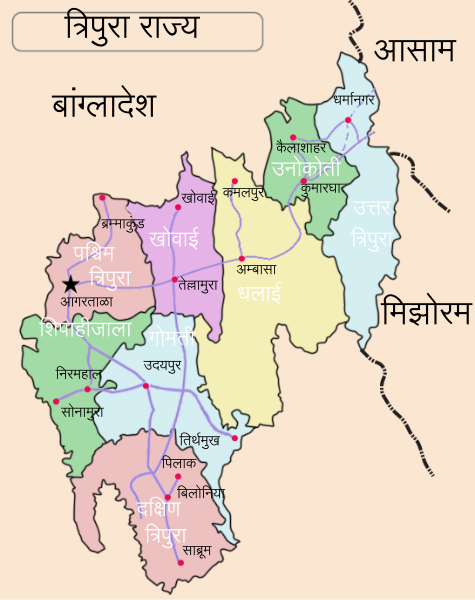
English: Locator map of the state of Tripura, India with district boundaries. |
| Date | |
| Source | File:Tripura-district-map.svg |
| Author | Translated into Marathi by User:Naik Ganesh Chandu |
Licensing[edit]
This file is licensed under the Creative Commons Attribution-Share Alike 4.0 International license.
- You are free:
- to share – to copy, distribute and transmit the work
- to remix – to adapt the work
- Under the following conditions:
- attribution – You must give appropriate credit, provide a link to the license, and indicate if changes were made. You may do so in any reasonable manner, but not in any way that suggests the licensor endorses you or your use.
- share alike – If you remix, transform, or build upon the material, you must distribute your contributions under the same or compatible license as the original.
File history
Click on a date/time to view the file as it appeared at that time.
| Date/Time | Thumbnail | Dimensions | User | Comment | |
|---|---|---|---|---|---|
| current | 10:22, 15 March 2019 | | 545 × 688 (229 KB) | TilmannR (talk | contribs) | Help:SVG#Black_rectangle_(Flowed_Text_bug) // Editing SVG source code using User:Rillke/SVGedit.js; upload handled by User:Rillke/MwJSBot.js |
| 09:57, 15 March 2019 |  | 545 × 688 (231 KB) | Naik Ganesh Chandu (talk | contribs) | User created page with UploadWizard |
You cannot overwrite this file.
File usage on Commons
There are no pages that use this file.