File:Trescott Ford, Staffordshire - geograph.org.uk - 1135616.jpg
Jump to navigation
Jump to search
No higher resolution available.
Trescott_Ford,_Staffordshire_-_geograph.org.uk_-_1135616.jpg (640 × 459 pixels, file size: 152 KB, MIME type: image/jpeg)
Captions
Captions
Add a one-line explanation of what this file represents
Summary[edit]
| Description |
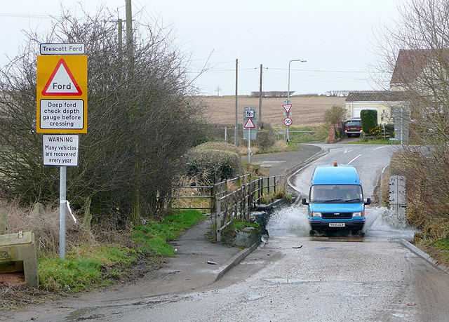
English: Trescott Ford, Staffordshire The Smestow Brook, which is prone to breaking its banks following heavy rain crosses the lane from Ebstree, Seisdon and Lower Penn, flowing from right to left. There are plenty of signs to warn self-confident motorists that this ford might be deeper than it appears. Today the water was only about 20cm in depth.
The Monarch's Way also uses this route, see our detailed gallery here: https://www.geograph.org.uk/gallery/the_monarch_s_way_7036 . |
| Date | |
| Source | From geograph.org.uk |
| Author | Roger Kidd |
| Attribution (required by the license) | Roger Kidd / Trescott Ford, Staffordshire / |
| Camera location | | View this and other nearby images on: OpenStreetMap |
|---|
_heading:292.00&language=en)
| Object location | | View this and other nearby images on: OpenStreetMap |
|---|
_heading:292.00&language=en)
Licensing[edit]

|
This image was taken from the Geograph project collection. See this photograph's page on the Geograph website for the photographer's contact details. The copyright on this image is owned by Roger Kidd and is licensed for reuse under the Creative Commons Attribution-ShareAlike 2.0 license.
|
This file is licensed under the Creative Commons Attribution-Share Alike 2.0 Generic license.
Attribution: Roger Kidd
- You are free:
- to share – to copy, distribute and transmit the work
- to remix – to adapt the work
- Under the following conditions:
- attribution – You must give appropriate credit, provide a link to the license, and indicate if changes were made. You may do so in any reasonable manner, but not in any way that suggests the licensor endorses you or your use.
- share alike – If you remix, transform, or build upon the material, you must distribute your contributions under the same or compatible license as the original.
File history
Click on a date/time to view the file as it appeared at that time.
| Date/Time | Thumbnail | Dimensions | User | Comment | |
|---|---|---|---|---|---|
| current | 05:16, 25 February 2011 | | 640 × 459 (152 KB) | GeographBot (talk | contribs) | == {{int:filedesc}} == {{Information |description={{en|1=Trescott Ford, Staffordshire The Smestow Brook, which is prone to breaking its banks following heavy rain crosses the lane from Ebstree, Seisdon and Lower Penn, flowing from right to left. There are |
You cannot overwrite this file.
File usage on Commons
There are no pages that use this file.