File:Trat Regionalna draha.PNG
Jump to navigation
Jump to search

Size of this preview: 800 × 400 pixels. Other resolutions: 320 × 160 pixels | 640 × 320 pixels.
Original file (1,201 × 600 pixels, file size: 138 KB, MIME type: image/png)
Captions
Captions
Add a one-line explanation of what this file represents

|
This map image could be re-created using vector graphics as an SVG file. This has several advantages; see Commons:Media for cleanup for more information. If an SVG form of this image is available, please upload it and afterwards replace this template with
{{vector version available|new image name}}.
It is recommended to name the SVG file “Trat Regionalna draha.svg”—then the template Vector version available (or Vva) does not need the new image name parameter. |
| Description |
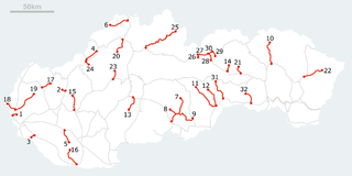
English: Map of Regionálna dráha |
||
| Source | Own work | ||
| Author | ENG-N1 | ||
| Permission (Reusing this file) |
|
File history
Click on a date/time to view the file as it appeared at that time.
| Date/Time | Thumbnail | Dimensions | User | Comment | |
|---|---|---|---|---|---|
| current | 11:16, 16 October 2010 | | 1,201 × 600 (138 KB) | ENG-N1 (talk | contribs) | cleanup |
| 15:50, 15 October 2010 |  | 1,203 × 600 (124 KB) | ENG-N1 (talk | contribs) | {{Information |Description={{en|1=Map of Regionálna dráha}} |Source=Self made |Author=ENG-N1 |Date= |Permission={{PD-self}} |other_versions= }} Category:Rail transport maps of Slovakia |
You cannot overwrite this file.
File usage on Commons
There are no pages that use this file.
File usage on other wikis
The following other wikis use this file:
- Usage on ja.wikipedia.org
- Usage on nl.wikipedia.org