File:Tram map of Minsk (Belarus), November 2018, in English.png
Jump to navigation
Jump to search
Size of this preview: 769 × 599 pixels. Other resolutions: 308 × 240 pixels | 616 × 480 pixels | 985 × 768 pixels | 1,293 × 1,008 pixels.
Original file (1,293 × 1,008 pixels, file size: 2.1 MB, MIME type: image/png)
Captions
Captions
Add a one-line explanation of what this file represents
Summary[edit]
,_November_2018,_in_English.png&action=edit§ion=1)
| Description |
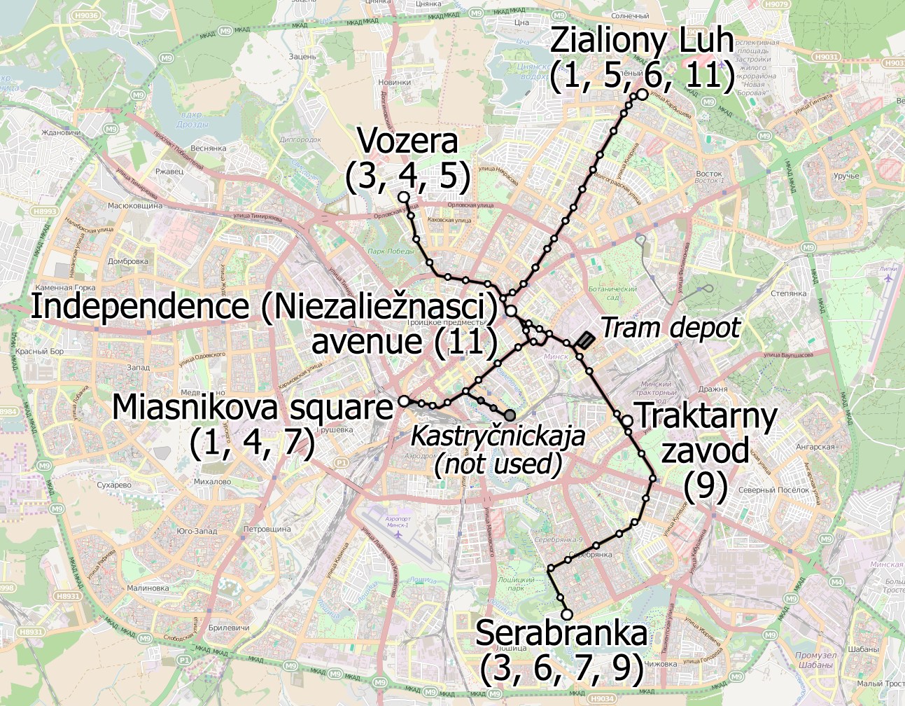
English: Tram map of Minsk (Belarus), November 2018 |
| Date | |
| Source | Own work, using OpenStreetMap as a basis |
| Author | Homoatrox (tram lines, inscriptions), OSM community (basis) |
| Other versions | File:Tram map of Minsk (Belarus), November 2018 — Схема трамвайных маршрутов в Минске (Беларусь), ноябрь 2018.png (in Russian), File:Трамвайныя лініі ў Мінску.png (in Belarusian) |
,_November_2018_%E2%80%94_%D0%A1%D1%85%D0%B5%D0%BC%D0%B0_%D1%82%D1%80%D0%B0%D0%BC%D0%B2%D0%B0%D0%B9%D0%BD%D1%8B%D1%85_%D0%BC%D0%B0%D1%80%D1%88%D1%80%D1%83%D1%82%D0%BE%D0%B2_%D0%B2_%D0%9C%D0%B8%D0%BD%D1%81%D0%BA%D0%B5_(%D0%91%D0%B5%D0%BB%D0%B0%D1%80%D1%83%D1%81%D1%8C),_%D0%BD%D0%BE%D1%8F%D0%B1%D1%80%D1%8C_2018.png)
Licensing[edit]
,_November_2018,_in_English.png&action=edit§ion=2)
I, the copyright holder of this work, hereby publish it under the following license:
This file is licensed under the Creative Commons Attribution-Share Alike 4.0 International license.
- You are free:
- to share – to copy, distribute and transmit the work
- to remix – to adapt the work
- Under the following conditions:
- attribution – You must give appropriate credit, provide a link to the license, and indicate if changes were made. You may do so in any reasonable manner, but not in any way that suggests the licensor endorses you or your use.
- share alike – If you remix, transform, or build upon the material, you must distribute your contributions under the same or compatible license as the original.
| Description |
This map was created from OpenStreetMap project data, collected by the community. This map may be incomplete, and may contain errors. Don't rely solely on it for navigation. |
|||
| Date | (see file history) | |||
| Source | openstreetmap.org | |||
| Creator |
OpenStreetMap contributors |
|||
| Permission (Reusing this file) |
OpenStreetMap data is available under the Open Database License (details). Map tiles are licensed under the Creative Commons Attribution-ShareAlike 2.0 license (CC-BY-SA 2.0).
This file is licensed under the Creative Commons Attribution-Share Alike 2.0 Generic license.
|
|||
| Georeferencing | If inappropriate please set warp_status = skip to hide. |
File history
Click on a date/time to view the file as it appeared at that time.
| Date/Time | Thumbnail | Dimensions | User | Comment | |
|---|---|---|---|---|---|
| current | 07:55, 2 July 2019 | | 1,293 × 1,008 (2.1 MB) | Homoatrox (talk | contribs) | +tram stops |
| 08:37, 28 November 2018 |  | 1,293 × 1,008 (2.06 MB) | Homoatrox (talk | contribs) | User created page with UploadWizard |
You cannot overwrite this file.
File usage on Commons
The following 10 pages use this file:
- Tram - Europe
- User:Chumwa/OgreBot/Potential transport maps/2018 November 21-30
- User:Chumwa/OgreBot/Potential transport maps/2019 July 1-10
- User:Chumwa/OgreBot/Public transport information/2018 November 21-30
- User:Chumwa/OgreBot/Public transport information/2019 July 1-10
- User:Chumwa/OgreBot/Transport Maps/2018 November 21-30
- User:Chumwa/OgreBot/Transport Maps/2019 July 1-10
- User:Chumwa/OgreBot/Travel and communication maps/2018 November 21-30
- User:Chumwa/OgreBot/Travel and communication maps/2019 July 1-10
- Category:Tram transport in Minsk
File usage on other wikis
The following other wikis use this file:
- Usage on cs.wikipedia.org
- Usage on de.wikipedia.org
- Usage on en.wikipedia.org
- Usage on fa.wikipedia.org
- Usage on fr.wikipedia.org
- Usage on hu.wikipedia.org
- Usage on it.wikipedia.org
- Usage on ja.wikipedia.org
- Usage on uk.wikipedia.org
- Usage on www.wikidata.org
,_November_2018,_in_English.png&oldid=516782601)