File:Traité de Bretigny-es.svg
Jump to navigation
Jump to search

Size of this PNG preview of this SVG file: 423 × 518 pixels. Other resolutions: 196 × 240 pixels | 392 × 480 pixels | 627 × 768 pixels | 836 × 1,024 pixels | 1,672 × 2,048 pixels.
Original file (SVG file, nominally 423 × 518 pixels, file size: 158 KB)
Captions
Captions
Add a one-line explanation of what this file represents
Summary[edit]
| Description |
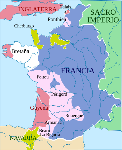
English: In red: territories controlled by Edward III. Pink: territories ceded by France to England under the Treaty of Brétigny in 1360.
Español: En rojo, territorios controlados por Eduardo III de Inglaterra. En rosa, territorios cedidos por Francia a Inglaterra por el Tratado de Bretigny de 1360. |
| Date | (UTC) |
| Source |
This file was derived from: Traité de Bretigny.svg:  |
| Author |
|
| This is a retouched picture, which means that it has been digitally altered from its original version. Modifications: translated into Spanish. The original can be viewed here: Traité de Bretigny.svg:
|
Licensing[edit]
This file is licensed under the Creative Commons Attribution-Share Alike 3.0 Unported license.
- You are free:
- to share – to copy, distribute and transmit the work
- to remix – to adapt the work
- Under the following conditions:
- attribution – You must give appropriate credit, provide a link to the license, and indicate if changes were made. You may do so in any reasonable manner, but not in any way that suggests the licensor endorses you or your use.
- share alike – If you remix, transform, or build upon the material, you must distribute your contributions under the same or compatible license as the original.
Original upload log[edit]
This image is a derivative work of the following images:
- File:Traité_de_Bretigny.svg licensed with Cc-by-sa-2.5,2.0,1.0, Cc-by-sa-3.0-migrated, GFDL
- 2007-12-12T22:15:09Z Cyberprout 423x518 (103780 Bytes) == Description == En rouge: territoires contrôlés par Edouard III. En rouge pâle: territoires cédés par la France à l'Angleterre en vertu du traité de Brétigny en 1360. Cette carte est mal fichue. La Bigorre est à l
- 2007-12-01T22:38:40Z Cyberprout 423x518 (91905 Bytes) == Description == En rouge: territoires contrôlés par Edouard III. En rouge pâle: territoires cédés par la France à l'Angleterre en vertu du traité de Brétigny en 1360. Cette carte est mal fichue. La Bigorre est à l
- 2007-12-01T22:38:00Z Cyberprout 423x518 (91905 Bytes) == Description == En rouge: territoires contrôlés par Edouard III. En rouge pâle: territoires cédés par la France à l'Angleterre en vertu du traité de Brétigny en 1360. Cette carte est mal fichue. La Bigorre est à l
- 2007-01-14T17:45:19Z Aliesin 423x518 (91882 Bytes) En rouge: territoires contrôlés par Edouard III. En rouge pâle: territoires cédés par la France à l'Angleterre en vertu du traité de Brétigny en 1360.
- 2007-01-13T21:51:36Z Aliesin 423x518 (43327 Bytes) En rouge: territoires contrôlés par Edouard III. En rouge pâle: territoires cédés par la France à l'Angleterre en vertu du traité de Brétigny en 1360.
Uploaded with derivativeFX
File history
Click on a date/time to view the file as it appeared at that time.
| Date/Time | Thumbnail | Dimensions | User | Comment | |
|---|---|---|---|---|---|
| current | 07:09, 30 August 2020 | | 423 × 518 (158 KB) | Rowanwindwhistler (talk | contribs) | Fake text added (real text hidden), minor changes |
| 06:41, 15 July 2016 |  | 423 × 518 (94 KB) | Rowanwindwhistler (talk | contribs) | https://en.wikipedia.org/wiki/Wikipedia:WikiProject_Maps/Conventions | |
| 16:21, 4 July 2013 |  | 423 × 518 (100 KB) | Rowanwindwhistler (talk | contribs) | == {{int:filedesc}} == {{Information |Description={{en|1=In red: territories controlled by Edward III. Pink: territories ceded by France to England under the Treaty of Brétigny in 1360.}} {{es|1=En rojo, territorios controlados por Eduardo III de Ingl... |
You cannot overwrite this file.
File usage on Commons
The following 3 pages use this file:
File usage on other wikis
The following other wikis use this file:
- Usage on es.wikipedia.org