File:Toronto map.png
Jump to navigation
Jump to search

Size of this preview: 800 × 595 pixels. Other resolutions: 320 × 238 pixels | 640 × 476 pixels | 1,024 × 761 pixels | 1,280 × 951 pixels | 1,500 × 1,115 pixels.
Original file (1,500 × 1,115 pixels, file size: 703 KB, MIME type: image/png)
Captions
Captions
Add a one-line explanation of what this file represents
|
| Description |
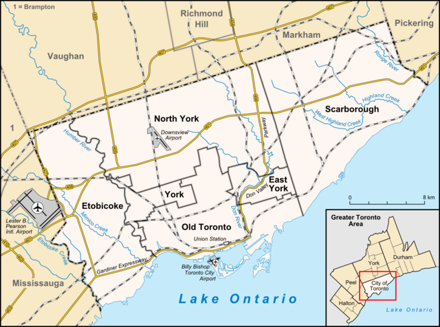
English: Map of Toronto
Français : Carte de Toronto
Deutsch: Karte von Toronto
Bahasa Indonesia: Peta kota Toronto |
| Date | |
| Source |
own work, used:
|
| Author | Lencer |

|
This map has been made or improved in the German Kartenwerkstatt (Map Lab). You can propose maps to improve as well.
|
This file is licensed under the Creative Commons Attribution-Share Alike 3.0 Unported license.
- You are free:
- to share – to copy, distribute and transmit the work
- to remix – to adapt the work
- Under the following conditions:
- attribution – You must give appropriate credit, provide a link to the license, and indicate if changes were made. You may do so in any reasonable manner, but not in any way that suggests the licensor endorses you or your use.
- share alike – If you remix, transform, or build upon the material, you must distribute your contributions under the same or compatible license as the original.
File history
Click on a date/time to view the file as it appeared at that time.
| Date/Time | Thumbnail | Dimensions | User | Comment | |
|---|---|---|---|---|---|
| current | 14:33, 3 April 2012 | | 1,500 × 1,115 (703 KB) | Lencer (talk | contribs) | + don river, minor adds of river names |
| 15:59, 29 June 2009 |  | 1,500 × 1,115 (585 KB) | SimonP (talk | contribs) | correct minor error | |
| 15:18, 29 June 2009 |  | 1,500 × 1,115 (585 KB) | SimonP (talk | contribs) | Corect East York border | |
| 10:56, 18 June 2009 |  | 1,500 × 1,115 (677 KB) | Lencer (talk | contribs) | + don valley parkway | |
| 18:56, 25 March 2009 |  | 1,500 × 1,115 (673 KB) | Lencer (talk | contribs) | Int. => Intl. | |
| 12:19, 18 March 2009 |  | 1,500 × 1,115 (672 KB) | Lencer (talk | contribs) | Vaugahn -> Vaughan | |
| 06:54, 10 March 2009 |  | 1,500 × 1,115 (673 KB) | Lencer (talk | contribs) | fix Greater Toronto Area | |
| 12:29, 9 March 2009 |  | 1,500 × 1,115 (672 KB) | Lencer (talk | contribs) | + Minimap, some fixes | |
| 19:10, 8 March 2009 |  | 1,500 × 1,116 (628 KB) | Lencer (talk | contribs) | weitere Kartenelemente erg., Farben geändert | |
| 20:02, 2 March 2009 |  | 1,500 × 1,116 (475 KB) | Lencer (talk | contribs) | Fehlerhafte Grenze bei York |
You cannot overwrite this file.
File usage on Commons
The following 15 pages use this file:
- File:East York locator.png
- File:Etobicoke locator.png
- File:North York Locator.png
- File:Old Toronto locator.png
- File:Scarborough locator.png
- File:Toronto Ward Map 1969.png
- File:Toronto Ward Map 1988.png
- File:Toronto Wikivoyage locator maps - Kensington-Chinatown.png
- File:Toronto Wikivoyage locator maps - Toronto Entertainment and Financial Districts.png
- File:Toronto Wikivoyage locator maps - Yonge-Dundas.png
- File:Toronto Wikivoyage locator maps - Yorkville and the Annex.png
- File:Toronto region wards 1988.png
- File:York locator.png
- Category:2018 Toronto van incident
- Category:Chinatown, Toronto
File usage on other wikis
The following other wikis use this file:
- Usage on ar.wikipedia.org
- Usage on ban.wikipedia.org
- Usage on ceb.wikipedia.org
- Usage on ckb.wikipedia.org
- Usage on de.wikipedia.org
- Toronto
- Benutzer:Lencer
- Wikipedia:Exzellente Bilder/Karten und Satellitenbilder
- Liste der Ortsteile von Toronto
- Wikipedia:Kartenwerkstatt/Archiv/2009-03
- Wikipedia:Kandidaten für exzellente Bilder/Archiv2009/6
- Datei:Toronto map.png
- Toronto Fire Services
- Taber Hill
- Wikipedia:Kartenwerkstatt/Schaufenster
- Wikipedia:Exzellente Bilder/Kleine Bilder
- Usage on en.wikipedia.org
- Toronto
- Rogers Centre
- Yonge–Dundas Square
- Billy Bishop Toronto City Airport
- Don River (Ontario)
- Forest Hill, Toronto
- Humber River (Ontario)
- The Annex
- Royal Ontario Museum
- Cabbagetown, Toronto
- Rosedale, Toronto
- The Beaches, Toronto
- High Park
- The Kingsway, Toronto
- Baby Point
- Bendale
- The Junction
- Little Italy, Toronto
- New Toronto
- Leslieville
- Kensington Market
- Scotiabank Arena
- Riverdale, Toronto
- Metropolitan Toronto
- Union Station (Toronto)
- Swansea, Toronto
- Parkdale, Toronto
- Rouge River (Ontario)
- Ontario Science Centre
- Black Creek Pioneer Village
- Agincourt, Toronto
View more global usage of this file.