File:Theoretical Search Area MH370.svg
Jump to navigation
Jump to search

Size of this PNG preview of this SVG file: 800 × 475 pixels. Other resolutions: 320 × 190 pixels | 640 × 380 pixels | 1,024 × 609 pixels | 1,280 × 761 pixels | 2,560 × 1,521 pixels | 1,156 × 687 pixels.
Original file (SVG file, nominally 1,156 × 687 pixels, file size: 531 KB)
Captions
Captions
Add a one-line explanation of what this file represents
Summary[edit]
| Description |
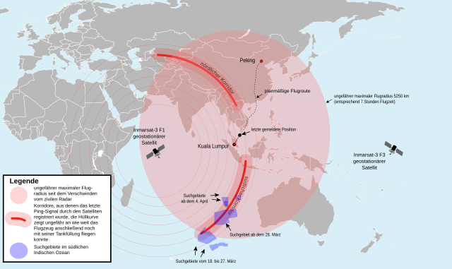
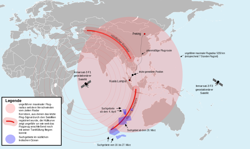
English: Map of the area where Malaysia Airlines Flight 370 could be found theoretically (svg version) (German).
Deutsch: Karte des Gebietes in dem sich der Malaysia-Airlines-Flug 370 theoretisch befinden könnte (svg-Version) (Deutsch).
中文(简体):马来西亚航空370号班机可能出现的区域 (德文)
中文(繁體):馬來西亞航空370號班機可能出現的區域 (德文) |
| Date | (UTC) |
| Source |
This file was derived from: Theoretical Search Area MH 370.png: |
| Author |
Vector: |
| SVG development |
Licensing[edit]
I, the copyright holder of this work, hereby publish it under the following license:
This file is licensed under the Creative Commons Attribution-Share Alike 2.0 Generic license.
- You are free:
- to share – to copy, distribute and transmit the work
- to remix – to adapt the work
- Under the following conditions:
- attribution – You must give appropriate credit, provide a link to the license, and indicate if changes were made. You may do so in any reasonable manner, but not in any way that suggests the licensor endorses you or your use.
- share alike – If you remix, transform, or build upon the material, you must distribute your contributions under the same or compatible license as the original.
Original upload log[edit]
This image is a derivative work of the following images:
- _ licensed with Cc-by-sa-2.0
- 2014-03-16T21:45:55Z Furfur 1881x1159 (249004 Bytes) Korridor enger gemacht, Satellitenname ergänzt
- 2014-03-15T19:23:15Z Furfur 1879x1160 (247882 Bytes) Grafik geändert nach Informationen von http://www.news.com.au/national/uighur-separatists-claim-over-missing-flight-mh370-may-be-reexamined/story-fncynjr2-1226855911080
- 2014-03-15T09:19:20Z Pechristener 2509x1548 (153746 Bytes) Kreis grösser mit einem Radius von 4800 km (gemäss Disk bei Kartenwerkstatt)
- 2014-03-15T08:17:57Z Pechristener 2509x1548 (152252 Bytes) {{Information |Description={{en|1=Map of the area, where [[:en: Malaysia Airlines Flight 370|Malaysia Airlines Flight 370]] could be found theoretically.}} {{de|1=Karte des Gebietes in dem sich der [[:de: Malaysia-Airlines-Fl
Uploaded with derivativeFX
File history
Click on a date/time to view the file as it appeared at that time.
| Date/Time | Thumbnail | Dimensions | User | Comment | |
|---|---|---|---|---|---|
| current | 14:46, 22 April 2016 | | 1,156 × 687 (531 KB) | Perhelion (talk | contribs) | typo (per hint on talkpage) |
| 21:14, 19 April 2015 |  | 1,156 × 687 (534 KB) | Perhelion (talk | contribs) | m | |
| 21:08, 19 April 2015 |  | 1,156 × 687 (535 KB) | Perhelion (talk | contribs) | fix font, cleaned | |
| 14:00, 5 April 2014 |  | 1,156 × 687 (1.46 MB) | Furfur (talk | contribs) | update according to http://www.bbc.com/news/world-asia-26514556 | |
| 09:42, 28 March 2014 |  | 1,102 × 688 (1.45 MB) | Furfur (talk | contribs) | Bildkosmetik | |
| 09:33, 28 March 2014 |  | 1,110 × 688 (1.45 MB) | Furfur (talk | contribs) | search areas specified, + new search area (source: Australian Maritime Safety Authority (Amsa) ) | |
| 19:12, 23 March 2014 |  | 1,146 × 680 (1.57 MB) | Pechristener (talk | contribs) | touchup: one '-' missing in 'Inmarsat-3' / drawing frame to avoid that label of flight radius kicks the ride border | |
| 17:07, 23 March 2014 |  | 1,063 × 672 (1.4 MB) | Furfur (talk | contribs) | enlarged the possible flight radius (compare http://www.bbc.com/news/world-asia-26705073), modified image legend, extended southern arc | |
| 10:04, 23 March 2014 |  | 1,068 × 699 (1.51 MB) | Pechristener (talk | contribs) | typo corrected / consequent capital & minuscule writing of the labels | |
| 09:57, 23 March 2014 |  | 1,068 × 699 (1.51 MB) | Pechristener (talk | contribs) | slight touchup: not bent or diagonal labels giving better rendering results / usual flight path instead of direct connetion (source: Flightradar24) / layers reorderd to have the satelite icon on the top / current search area added as indicated on graph... |
You cannot overwrite this file.
File usage on Commons
The following 16 pages use this file:
- Search for Malaysia Airlines Flight 370
- User:Chumwa/OgreBot/Potential transport maps/2016 April 21-30
- User:Chumwa/OgreBot/Transport Maps/2015 April 11-20
- User:Chumwa/OgreBot/Transport Maps/2016 April 21-30
- User:Chumwa/OgreBot/Travel and communication maps/2016 April 21-30
- User:Pechristener
- Commons:WikiProject Aviation/recent uploads/2014 March 16
- Commons:WikiProject Aviation/recent uploads/2015 April 19
- Commons:WikiProject Aviation/recent uploads/2016 April 22
- File:Map of search for MH370.png
- File:Theoretical Search Area MH370.zh-hans.svg
- File:Theoretical Search Area MH370.zh-hant.svg
- File:Theoretical Search Area MH 370.png
- File:Theoretical Search Area of MH370 v.3.png
- File:Vuelo 370 es.png
- File:Área 17mar MH370.PNG
File usage on other wikis
The following other wikis use this file:
- Usage on de.wikipedia.org
- Usage on gl.wikipedia.org
- Usage on no.wikipedia.org
- Usage on sh.wikipedia.org
- Usage on ug.wikipedia.org
- Usage on uk.wikipedia.org