File:Thembalethu Zones.png
Jump to navigation
Jump to search

Size of this preview: 800 × 557 pixels. Other resolutions: 320 × 223 pixels | 640 × 445 pixels | 1,024 × 713 pixels | 1,131 × 787 pixels.
Original file (1,131 × 787 pixels, file size: 168 KB, MIME type: image/png)
Captions
Captions
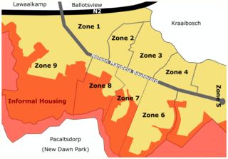
Zone divisions of Thembalethu.
Summary
[edit]
| Description |
English: This is a diagram showing the zones of Thembalethu and the informal housing linked to the township. This diagram was drawn with reference to a George Municipality Spatial Plan Map. |
| Date | |
| Source | Own work |
| Author | Esihle Hondwana |
Licensing
[edit]
I, the copyright holder of this work, hereby publish it under the following license:
This file is licensed under the Creative Commons Attribution-Share Alike 4.0 International license.
- You are free:
- to share – to copy, distribute and transmit the work
- to remix – to adapt the work
- Under the following conditions:
- attribution – You must give appropriate credit, provide a link to the license, and indicate if changes were made. You may do so in any reasonable manner, but not in any way that suggests the licensor endorses you or your use.
- share alike – If you remix, transform, or build upon the material, you must distribute your contributions under the same or compatible license as the original.
File history
Click on a date/time to view the file as it appeared at that time.
| Date/Time | Thumbnail | Dimensions | User | Comment | |
|---|---|---|---|---|---|
| current | 08:57, 1 June 2020 | | 1,131 × 787 (168 KB) | Esihle Hondwana (talk | contribs) | Better edited |
| 08:56, 1 June 2020 |  | 1,200 × 881 (175 KB) | Esihle Hondwana (talk | contribs) | Added Road Names | |
| 08:45, 1 June 2020 |  | 1,131 × 787 (158 KB) | Esihle Hondwana (talk | contribs) | Uploaded own work with UploadWizard |
You cannot overwrite this file.
File usage on Commons
There are no pages that use this file.
File usage on other wikis
The following other wikis use this file:
- Usage on en.wikipedia.org