File:The navigation officer on a Boeing 707 aircraft, leaving Rhein Main Air Base, Germany, plots a course using a laptop computer in connection with the Joint Surveillance Target Attack Radar System (J-STARS) 960219-A-KF633-004.jpg
Jump to navigation
Jump to search

Size of this preview: 800 × 527 pixels. Other resolutions: 320 × 211 pixels | 640 × 422 pixels | 1,024 × 675 pixels | 1,499 × 988 pixels.
Original file (1,499 × 988 pixels, file size: 480 KB, MIME type: image/jpeg)
Captions
Captions
Add a one-line explanation of what this file represents
Summary[edit]
_960219-A-KF633-004.jpg&action=edit§ion=1)
| Description |
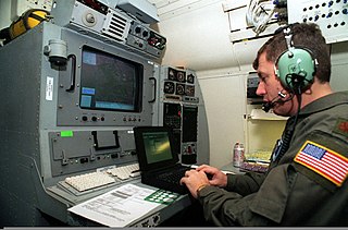
English: The navigation officer on a Boeing 707 aircraft, leaving Rhein Main Air Base, Germany, plots a course using a laptop computer in connection with the Joint Surveillance Target Attack Radar System (J-STARS). J-STARS is a long range, air-to-ground surveillance and battle management system. When in flight the radar can detect and track more than 120 miles of terrain providing the battle commander with invaluable information about troop movement and position. A 40-foot radome under the forward part of the fuselage houses the phased-array radar antenna. The information is fed to the 17 Army and Air Force operators who have access to the radar data in real-time via on-board large-screen graphics consoles. The radar data is simultaneously transmitted via secure data links to the Ground Station Modules (GSM) located throughout the theater for Operation Joint Endeavor. The GSMÕs for Operation Joint Endeavor are located in Hungary, Italy and Bosnia -Herzegovina. Run solely by the Army, these GSMÕs are integrated into Echelons Above Corps, Corps, Division, and Brigade to support maneuver, intelligence and fire support systems. Here, after receiving a request from a GSM, the navigation officer plots a course to provide the best coverage to those stations while still covering their original mission. |
| Date | 19 February 1996 |
| Source | http://www.defenseimagery.mil/imageRetrieve.action?guid=f15f75b793ae21e8869e778bd27f7454f53fc657&t=2 |
| Author | SGT Larry Aaron (USA) |
| Permission (Reusing this file) |
Public domain photograph from defenseimagery.mil. |
| Location | Unknown location |
| VIRIN | 960219-A-KF633-004 |
| Gallery page | http://www.defenseimagery.mil/imagery.html?&guid=f15f75b793ae21e8869e778bd27f7454f53fc657 |
Licensing[edit]
_960219-A-KF633-004.jpg&action=edit§ion=2)
This image is a work of a U.S. military or Department of Defense employee, taken or made as part of that person's official duties. As a work of the U.S. federal government, the image is in the public domain in the United States.
|
 |
File history
Click on a date/time to view the file as it appeared at that time.
| Date/Time | Thumbnail | Dimensions | User | Comment | |
|---|---|---|---|---|---|
| current | 19:00, 1 April 2013 | | 1,499 × 988 (480 KB) | Fæ (talk | contribs) | {{User:{{subst:User:Fae/Fae}}/milim | description = {{en|The navigation officer on a Boeing 707 aircraft, leaving Rhein Main Air Base, Germany, plots a course using a laptop computer in connection with the Joint Surveillance Target Attack Radar System ... |
You cannot overwrite this file.
File usage on Commons
There are no pages that use this file.
_960219-A-KF633-004.jpg&oldid=863162487)