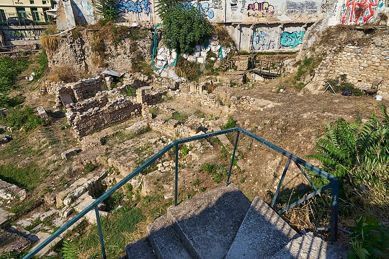
File:The excavations on the North Side of the Ancient Agora of Athens on 13 August 2020.jpg

Original file (6,000 × 4,000 pixels, file size: 39.62 MB, MIME type: image/jpeg)
Captions
Captions
Summary[edit]
| DescriptionThe excavations on the North Side of the Ancient Agora of Athens on 13 August 2020.jpg |
English: “CURRENT EXCAVATIONS AT THE NORTH SIDE OF THE ANCIENT ATHENIAN AGORA
The remains you see in front of you are tentatively identified as those of the Stoa Poikile (Painted Stoa), dating to ca. 475-465 B.C. In Greek architecture a stoa was any long colonnaded building; this one had Doric columns outside and Ionic columns within. It was named from the handsome wooden panel paintings, among the most famous in antiquity, which were hung on its walls soon after its construction. A description written by the traveler Pausanias in ca. 150 A.D. tells us that they showed Athenian military triumphs, both mythological and historical. By 400 A.D. a Roman proconsul had removed the paintings and they do not survive. The building was also famous as the classroom of the philosopher Zeno, who came to Athens in the years around 300 B.C. Meeting here regularly, he and his followers became known as the Stoics. Behind is a shop building originally built in the years around 420 B.C. and used with alterations, until the 5th century A.D. Both the stoa and the shops were abandoned by the 6th century A.D. and after several centuries their remains were covered by a neighborhood of houses and shops dating from the 10th to the 12th centuries A.D. The area is part of the ancient Athenian Agora, which has been under excavation since 1931 by the American School of Classical Studies in Athens, in cooperation with the Ephorate of Antiquities of Athens and the Hellenic Ministry of Culture. Funding comes largely from private American sources, especially the Pachard Humanities Institute.” Text: Site marker on Adrianou Street. |
| Date | |
| Source | Own work |
| Author | George E. Koronaios |
| Camera location | 37° 58′ 34.36″ N, 23° 43′ 21.46″ E | View this and other nearby images on: OpenStreetMap |
|---|
Licensing[edit]
| This file is made available under the Creative Commons CC0 1.0 Universal Public Domain Dedication. | |
| The person who associated a work with this deed has dedicated the work to the public domain by waiving all of their rights to the work worldwide under copyright law, including all related and neighboring rights, to the extent allowed by law. You can copy, modify, distribute and perform the work, even for commercial purposes, all without asking permission.
http://creativecommons.org/publicdomain/zero/1.0/deed.enCC0Creative Commons Zero, Public Domain Dedicationfalsefalse |
File history
Click on a date/time to view the file as it appeared at that time.
| Date/Time | Thumbnail | Dimensions | User | Comment | |
|---|---|---|---|---|---|
| current | 09:51, 14 August 2020 |  | 6,000 × 4,000 (39.62 MB) | George E. Koronaios (talk | contribs) | Uploaded own work with UploadWizard |
You cannot overwrite this file.
File usage on Commons
There are no pages that use this file.
File usage on other wikis
The following other wikis use this file:
- Usage on el.wiktionary.org
Metadata
This file contains additional information such as Exif metadata which may have been added by the digital camera, scanner, or software program used to create or digitize it. If the file has been modified from its original state, some details such as the timestamp may not fully reflect those of the original file. The timestamp is only as accurate as the clock in the camera, and it may be completely wrong.
| Camera manufacturer | SONY |
|---|---|
| Camera model | ILCE-7 |
| Exposure time | 1/640 sec (0.0015625) |
| F-number | f/5.6 |
| ISO speed rating | 100 |
| Date and time of data generation | 16:31, 13 August 2020 |
| Lens focal length | 24 mm |
| Horizontal resolution | 300 dpi |
| Vertical resolution | 300 dpi |
| Software used | Capture One 12.1.4 Windows |
| Exposure Program | Aperture priority |
| Exif version | 2.3 |
| Date and time of digitizing | 16:31, 13 August 2020 |
| APEX shutter speed | 9.321928 |
| APEX aperture | 4.970854 |
| APEX brightness | 9.74375 |
| APEX exposure bias | 0 |
| Maximum land aperture | 0.96875 APEX (f/1.4) |
| Metering mode | Pattern |
| Light source | Unknown |
| Flash | Flash did not fire, compulsory flash suppression |
| File source | Digital still camera |
| Scene type | A directly photographed image |
| Custom image processing | Normal process |
| Exposure mode | Auto exposure |
| White balance | Auto white balance |
| Digital zoom ratio | 1 |
| Focal length in 35 mm film | 24 mm |
| Scene capture type | Standard |
| Contrast | Normal |
| Saturation | Normal |
| Sharpness | Normal |
| Lens used | FE 24mm F1.4 GM |
| IIM version | 4 |