File:The Strait of Gibraltar.jpg
From Wikimedia Commons, the free media repository
Jump to navigation
Jump to search

Size of this preview: 614 × 600 pixels. Other resolutions: 246 × 240 pixels | 492 × 480 pixels | 787 × 768 pixels | 1,049 × 1,024 pixels | 2,500 × 2,441 pixels.
Original file (2,500 × 2,441 pixels, file size: 1.72 MB, MIME type: image/jpeg)
File information
Structured data
Captions
Captions
Add a one-line explanation of what this file represents
Summary[edit]
| The Strait of Gibraltar | |
|---|---|
| Photographer |
Envisat satellite |
| Title |
The Strait of Gibraltar |
| Description |
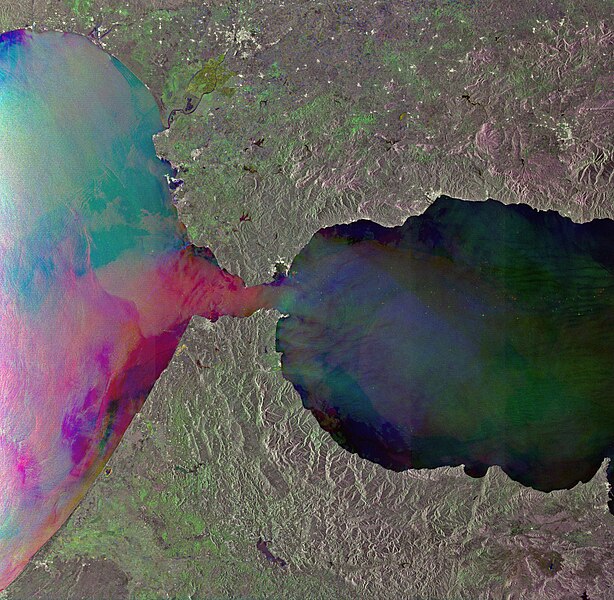
English: This Envisat radar image shows internal waves in the Strait of Gibraltar, between the southern coast of Spain (top) and the northern coast of Morocco. From space, internal waves can be detected very efficiently using Synthetic Aperture Radar (SAR) instruments that are sensitive to changes in the small-scale surface roughness on the ocean surface. Internal waves in this image show up as a semi-circular rippled pattern east of the strait’s entrance in the Mediterranean Sea. Additional sets of internal waves generated in the Atlantic Ocean are visible as dark pink lines on the western side of the strait. This image was created by combining three Envisat SAR acquisitions (12 August 2010, 1 October 2009 and 27 August 2009) over the same area. The colours result from changes in the surface between acquisitions. |
| Depicted place | Strait of Gibraltar |
| Date |
between 27 August 2009 and 12 August 2010 date QS:P571,+2050-00-00T00:00:00Z/7,P1319,+2009-08-27T00:00:00Z/11,P1326,+2010-08-12T00:00:00Z/11 |
| Collection | European Space Agency |
| Accession number |
231848 |
| Credit line | ESA |
| Source | http://www.esa.int/spaceinimages/Images/2010/10/The_Strait_of_Gibraltar |
Licensing[edit]
This media was created by the European Space Agency (ESA).
Where expressly so stated, images or videos are covered by the Creative Commons Attribution-ShareAlike 3.0 IGO (CC BY-SA 3.0 IGO) licence, ESA being an Intergovernmental Organisation (IGO), as defined by the CC BY-SA 3.0 IGO licence. The user is allowed under the terms and conditions of the CC BY-SA 3.0 IGO license to Reproduce, Distribute and Publicly Perform the ESA images and videos released under CC BY-SA 3.0 IGO licence and the Adaptations thereof, without further explicit permission being necessary, for as long as the user complies with the conditions and restrictions set forth in the CC BY-SA 3.0 IGO licence, these including that:
See the ESA Creative Commons copyright notice for complete information, and this article for additional details.
|
 | |
This file is licensed under the Creative Commons Attribution-ShareAlike 3.0 IGO license.
| ||
File history
Click on a date/time to view the file as it appeared at that time.
| Date/Time | Thumbnail | Dimensions | User | Comment | |
|---|---|---|---|---|---|
| current | 16:10, 2 September 2023 |  | 2,500 × 2,441 (1.72 MB) | Don-vip (talk | contribs) | Reverted to version as of 08:42, 25 February 2017 (UTC) |
| 16:08, 2 September 2023 |  | 3,971 × 4,060 (10.66 MB) | OptimusPrimeBot (talk | contribs) | #Spacemedia - Upload of https://www.copernicus.eu/system/files/2022-02/image_day/20220219_StraitOfGibraltar.jpg via Commons:Spacemedia | |
| 08:42, 25 February 2017 |  | 2,500 × 2,441 (1.72 MB) | Revent (talk | contribs) | =={{int:filedesc}}== {{Photograph |photographer = Envisat satellite |title = The Strait of Gibraltar |description = {{en|1=This Envisat radar image shows internal waves in the Strait of Gibraltar, between the southern coast... |
You cannot overwrite this file.
File usage on Commons
The following 4 pages use this file:
Metadata
This file contains additional information such as Exif metadata which may have been added by the digital camera, scanner, or software program used to create or digitize it. If the file has been modified from its original state, some details such as the timestamp may not fully reflect those of the original file. The timestamp is only as accurate as the clock in the camera, and it may be completely wrong.
| Width | 5,601 px |
|---|---|
| Height | 5,940 px |
| Compression scheme | Uncompressed |
| Pixel composition | RGB |
| Orientation | Normal |
| Number of components | 4 |
| Horizontal resolution | 72 dpi |
| Vertical resolution | 72 dpi |
| Software used | Adobe Photoshop CS4 Windows |
| File change date and time | 14:25, 6 October 2010 |
| Color space | Uncalibrated |
| Image width | 2,500 px |
| Image height | 2,441 px |
| Bits per component |
|
| Date and time of digitizing | 19:50, 14 September 2010 |
| Date metadata was last modified | 16:25, 6 October 2010 |
| Unique ID of original document | xmp.did:976AD94819C0DF1189F4D5C959E4A00A |

