File:The Norman Conquests.png
Jump to navigation
Jump to search
Size of this preview: 800 × 503 pixels. Other resolutions: 320 × 201 pixels | 640 × 403 pixels | 1,024 × 644 pixels | 1,280 × 805 pixels | 2,541 × 1,599 pixels.
Original file (2,541 × 1,599 pixels, file size: 329 KB, MIME type: image/png)
Captions
Captions
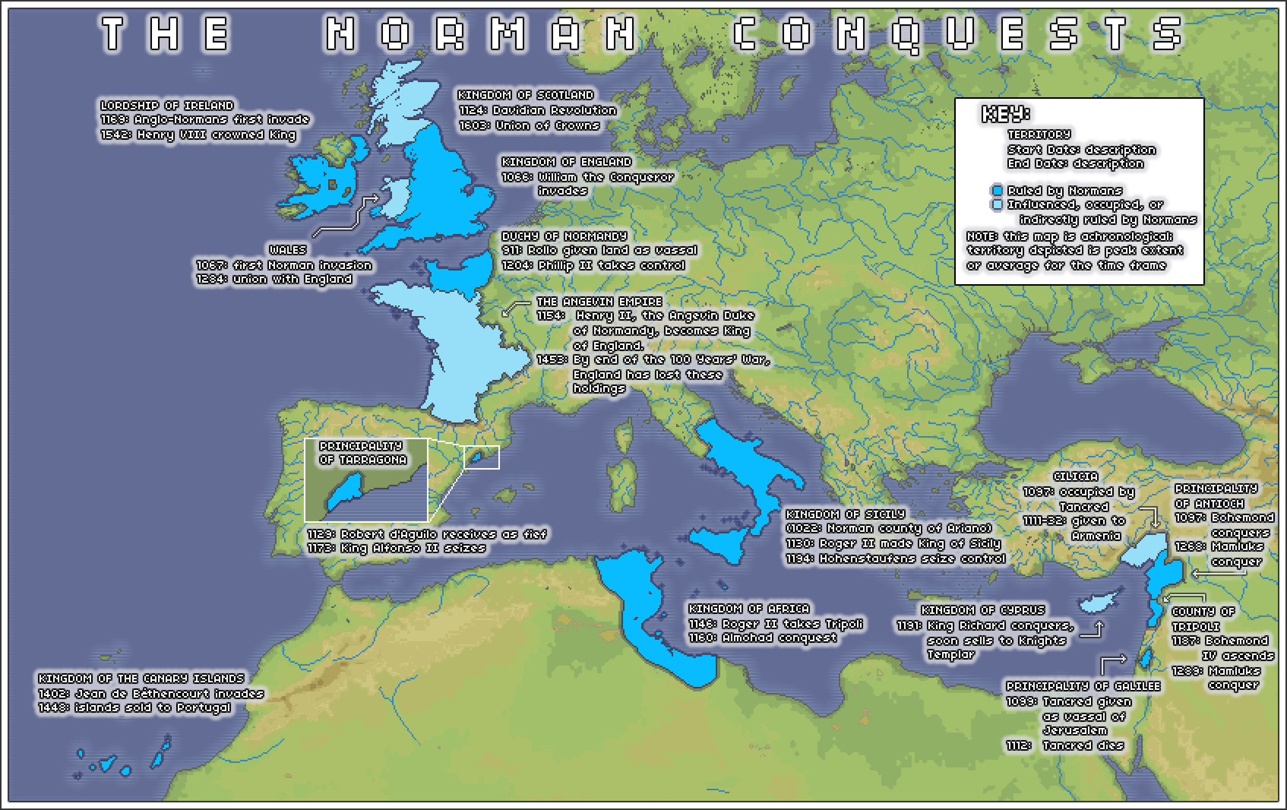
An achronological map of the lands conquered or ruled directly or indirectly by Normans.
Summary[edit]
| Description |
English: Lands depicted in this map include the Kingdom of England, the Lordship or Ireland, Wales, the Kingdom of Scotland, the Duchy of Normandy, the Principality of Tarragona, the Kingdoms of Sicily and Africa, the Kingdom of the Canary Islands, the brief Kingdom of Cyprus, areas of Cilicia occupied by Tancred, the Principality of Antioch, the County of Tripoli, and the Principality of Galilee. |
| Date | |
| Source | Own work |
| Author | Wildviper121 |
Licensing[edit]
I, the copyright holder of this work, hereby publish it under the following license:
This file is licensed under the Creative Commons Attribution-Share Alike 4.0 International license.
- You are free:
- to share – to copy, distribute and transmit the work
- to remix – to adapt the work
- Under the following conditions:
- attribution – You must give appropriate credit, provide a link to the license, and indicate if changes were made. You may do so in any reasonable manner, but not in any way that suggests the licensor endorses you or your use.
- share alike – If you remix, transform, or build upon the material, you must distribute your contributions under the same or compatible license as the original.
File history
Click on a date/time to view the file as it appeared at that time.
| Date/Time | Thumbnail | Dimensions | User | Comment | |
|---|---|---|---|---|---|
| current | 02:47, 25 March 2022 | | 2,541 × 1,599 (329 KB) | Wildviper121 (talk | contribs) | Updated border of Tarragona |
| 15:04, 24 March 2022 |  | 2,541 × 1,599 (316 KB) | Wildviper121 (talk | contribs) | Uploaded own work with UploadWizard |
You cannot overwrite this file.
File usage on Commons
There are no pages that use this file.