File:The Administrative Divisions of Safavid Iran in the the South Caucasus.svg
Jump to navigation
Jump to search

Size of this PNG preview of this SVG file: 625 × 600 pixels. Other resolutions: 250 × 240 pixels | 500 × 480 pixels | 800 × 768 pixels | 1,067 × 1,024 pixels | 2,133 × 2,048 pixels | 2,646 × 2,540 pixels.
Original file (SVG file, nominally 2,646 × 2,540 pixels, file size: 9.24 MB)
Captions
Captions
Add a one-line explanation of what this file represents
Summary[edit]
| Description |
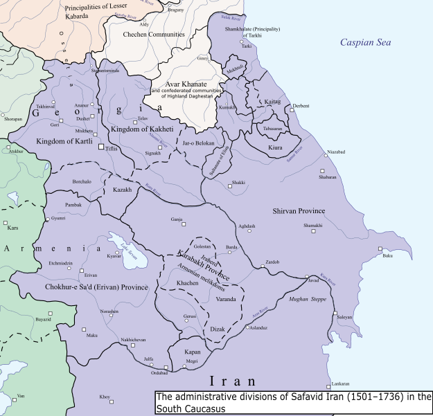
English: The Administrative Divisions of Safavid Iran in the the South Caucasus. |
| Date | |
| Source |
Own work Based on:
|
| Author | HistoryofIran |
Licensing[edit]
I, the copyright holder of this work, hereby publish it under the following license:
This file is licensed under the Creative Commons Attribution-Share Alike 4.0 International license.
- You are free:
- to share – to copy, distribute and transmit the work
- to remix – to adapt the work
- Under the following conditions:
- attribution – You must give appropriate credit, provide a link to the license, and indicate if changes were made. You may do so in any reasonable manner, but not in any way that suggests the licensor endorses you or your use.
- share alike – If you remix, transform, or build upon the material, you must distribute your contributions under the same or compatible license as the original.
File history
Click on a date/time to view the file as it appeared at that time.
| Date/Time | Thumbnail | Dimensions | User | Comment | |
|---|---|---|---|---|---|
| current | 13:18, 23 September 2023 | | 2,646 × 2,540 (9.24 MB) | HistoryofIran (talk | contribs) | added Shamkhalate of Tarkhi |
| 17:54, 12 September 2023 |  | 2,646 × 2,540 (9.21 MB) | HistoryofIran (talk | contribs) | small adjustments | |
| 21:07, 3 September 2023 |  | 2,646 × 2,540 (9.22 MB) | HistoryofIran (talk | contribs) | == {{int:filedesc}} == {{Information |description={{en|1=The Administrative Divisions of Safavid Iran in the the South Caucasus.}} |date=2024-09-03 |source={{own}} Based on: * Tsutsiev, Arthur (2014). Atlas of the Ethno-Political History of the Caucasus. Yale University Press. {{ISBN|978-0300153088}}. |author=HistoryofIran |permission= |other versions= }} =={{int:license-header}}== {{self|cc-by-sa-4.0}} Category:SVG maps of the history of Azerbaijan [[Category:... |
You cannot overwrite this file.
File usage on Commons
The following 3 pages use this file:
File usage on other wikis
The following other wikis use this file:
- Usage on en.wikipedia.org
- Usage on fa.wikipedia.org
- Usage on ka.wikipedia.org
- Usage on uz.wikipedia.org
Metadata
Categories:
- SVG maps of the history of Azerbaijan
- Maps of the history of Armenia
- Maps of the history of Georgia
- Maps of the history of the south Caucasus region
- Maps of the history of the Caucasus
- Maps of the history of Iran
- History of Derbent
- English-language SVG maps showing history
- Maps of the history of Dagestan
- Maps showing 16th-century history
- Maps showing 17th-century history
- Maps showing 18th-century history
- Kingdom of Kartli
- Maps of the Safavid Empire
- Shamkhalate of Tarki
- Kingdom of Kakheti
- Avar Khanate