File:The A148 (Holt Road) past the Letheringsett Brewery - geograph.org.uk - 1025693.jpg
Jump to navigation
Jump to search
Size of this preview: 450 × 600 pixels. Other resolutions: 180 × 240 pixels | 480 × 640 pixels.
Original file (480 × 640 pixels, file size: 147 KB, MIME type: image/jpeg)
Captions
Captions
Add a one-line explanation of what this file represents
Summary[edit]
_past_the_Letheringsett_Brewery_-_geograph.org.uk_-_1025693.jpg&action=edit§ion=1)
| Description |
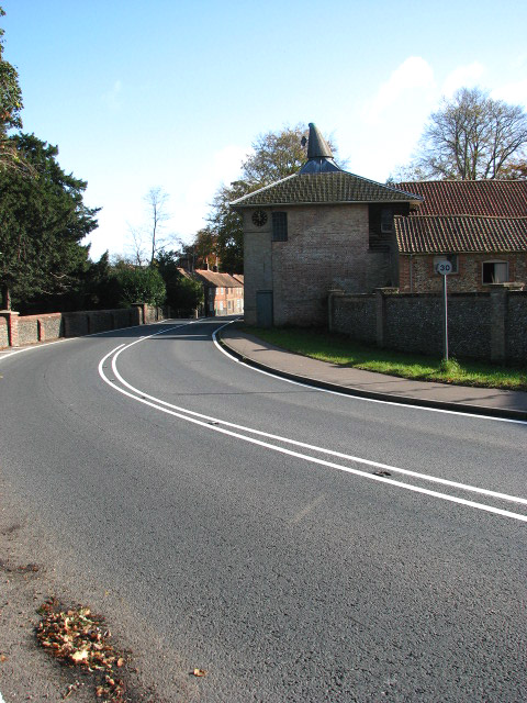
English: The A148 (Holt Road) past the Letheringsett Brewery The view was taken in easterly direction. The maltings of the former Letheringsett Brewery can be seen at right.
The brewery was built in 1783 by William Hardy from East Dereham, who conducted his business as a maltster from Coltishall, using his own wherry for the transport of goods. After moving to Letheringsett Hall with his family in 1781, he purchased the maltings and Hagan's brewery, situated across the road from the Hall, and there built the Letheringsett Brewery, originally constructed to function as a malt mill. The maltings are built from gault brick with some flint and have a hipped roof. Later a new mill was built within the existing main building and the first wheat ground here was sold in December 1784. Part of the complex is presently used for general storage. |
| Date | |
| Source | From geograph.org.uk |
| Author | Evelyn Simak |
| Attribution (required by the license) | Evelyn Simak / The A148 (Holt Road) past the Letheringsett Brewery / |
| Camera location | | View this and other nearby images on: OpenStreetMap |
|---|
_past_the_Letheringsett_Brewery_-_geograph.org.uk_-_1025693.jpg¶ms=052.907690_N_0001.062900_E_globe:Earth_type:camera_source:geograph-osgb36(TG06063886)_heading:90.00&language=en)
| Object location | | View this and other nearby images on: OpenStreetMap |
|---|
_past_the_Letheringsett_Brewery_-_geograph.org.uk_-_1025693.jpg¶ms=052.907570_N_0001.063900_E_globe:Earth_class:object_type:object_source:geograph-osgb36(TG06133885)_heading:90.00&language=en)
Licensing[edit]
_past_the_Letheringsett_Brewery_-_geograph.org.uk_-_1025693.jpg&action=edit§ion=2)

|
This image was taken from the Geograph project collection. See this photograph's page on the Geograph website for the photographer's contact details. The copyright on this image is owned by Evelyn Simak and is licensed for reuse under the Creative Commons Attribution-ShareAlike 2.0 license.
|
This file is licensed under the Creative Commons Attribution-Share Alike 2.0 Generic license.
Attribution: Evelyn Simak
- You are free:
- to share – to copy, distribute and transmit the work
- to remix – to adapt the work
- Under the following conditions:
- attribution – You must give appropriate credit, provide a link to the license, and indicate if changes were made. You may do so in any reasonable manner, but not in any way that suggests the licensor endorses you or your use.
- share alike – If you remix, transform, or build upon the material, you must distribute your contributions under the same or compatible license as the original.
File history
Click on a date/time to view the file as it appeared at that time.
| Date/Time | Thumbnail | Dimensions | User | Comment | |
|---|---|---|---|---|---|
| current | 15:42, 23 February 2011 | | 480 × 640 (147 KB) | GeographBot (talk | contribs) | == {{int:filedesc}} == {{Information |description={{en|1=The A148 (Holt Road) past the Letheringsett Brewery The view was taken in easterly direction. The maltings of the former Letheringsett Brewery can be seen at right. The brewery was built in 1783 |
You cannot overwrite this file.
File usage on Commons
There are no pages that use this file.
_past_the_Letheringsett_Brewery_-_geograph.org.uk_-_1025693.jpg&oldid=717902716)