File:Tenasserim Hills-Southeast asia.jpg
Jump to navigation
Jump to search

Size of this preview: 568 × 599 pixels. Other resolutions: 227 × 240 pixels | 633 × 668 pixels.
Original file (633 × 668 pixels, file size: 98 KB, MIME type: image/jpeg)
Captions
Captions
Add a one-line explanation of what this file represents
Summary[edit]
| Description |
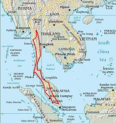
English: Extent of the Tenasserim Hills and their subranges |
| Date | |
| Source | Southeast Asia map from CIA World Factbook |
| Author | https://www.cia.gov/library/publications/the-world-factbook/index.html |
Licensing[edit]
This image is in the public domain because it contains materials that originally came from the United States Central Intelligence Agency's World Factbook.
|
 |
File history
Click on a date/time to view the file as it appeared at that time.
| Date/Time | Thumbnail | Dimensions | User | Comment | |
|---|---|---|---|---|---|
| current | 11:28, 13 December 2011 | | 633 × 668 (98 KB) | Xufanc (talk | contribs) | refined northern end limit |
| 09:29, 10 December 2011 |  | 638 × 680 (99 KB) | Xufanc (talk | contribs) |
You cannot overwrite this file.
File usage on Commons
The following page uses this file:
File usage on other wikis
The following other wikis use this file:
- Usage on ca.wikipedia.org
- Usage on en.wikipedia.org
- Usage on eo.wikipedia.org
- Usage on es.wikipedia.org
- Usage on eu.wikipedia.org
- Usage on fr.wikipedia.org
- Usage on id.wikipedia.org
- Usage on it.wikipedia.org
- Usage on ml.wikipedia.org
- Usage on ms.wikipedia.org
- Usage on mt.wikipedia.org
- Usage on my.wikipedia.org
- Usage on pt.wikipedia.org
- Usage on sv.wikipedia.org
- Usage on ta.wikipedia.org
- Usage on th.wikipedia.org
- Usage on www.wikidata.org
- Usage on zh.wikipedia.org