File:Tectonic plates (2022) es.svg
Jump to navigation
Jump to search

Size of this PNG preview of this SVG file: 800 × 406 pixels. Other resolutions: 320 × 163 pixels | 640 × 325 pixels | 1,024 × 520 pixels | 1,280 × 650 pixels | 2,560 × 1,300 pixels | 1,920 × 975 pixels.
Original file (SVG file, nominally 1,920 × 975 pixels, file size: 355 KB)
Captions
Captions
Add a one-line explanation of what this file represents
Summary[edit]
_es.svg&action=edit§ion=1)
| Description |
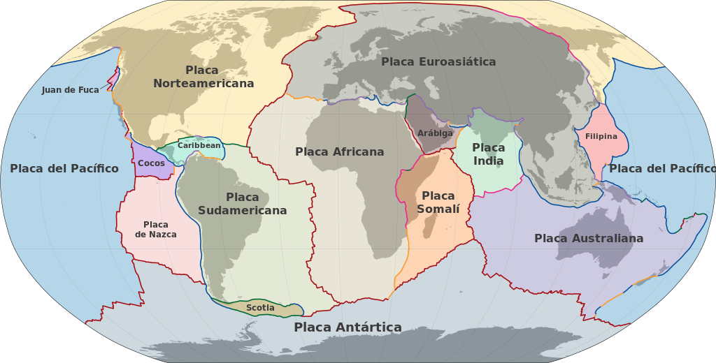
Español: Mapa de las principales placas tectónicas de la tierra. Tipos de límites de placa: Centro de expansión
Zona de extensión
Convergent: Zona de subducción
Zona de colisión
Transformante: Transformante dextral
Transformante sinistral |
| Date | |
| Source | M.Bitton, basado en Hasterok, Derrick (8 June 2022). New maps of global geological provinces and tectonic plates. American Institute of Physics - Phys.org. Retrieved on 27 March 2023. |
| Author | M.Bitton Translated by:Insnay |
Licensing[edit]
_es.svg&action=edit§ion=2)
I, the copyright holder of this work, hereby publish it under the following license:
This file is licensed under the Creative Commons Attribution-Share Alike 4.0 International license.
- You are free:
- to share – to copy, distribute and transmit the work
- to remix – to adapt the work
- Under the following conditions:
- attribution – You must give appropriate credit, provide a link to the license, and indicate if changes were made. You may do so in any reasonable manner, but not in any way that suggests the licensor endorses you or your use.
- share alike – If you remix, transform, or build upon the material, you must distribute your contributions under the same or compatible license as the original.
File history
Click on a date/time to view the file as it appeared at that time.
| Date/Time | Thumbnail | Dimensions | User | Comment | |
|---|---|---|---|---|---|
| current | 11:21, 10 November 2023 | | 1,920 × 975 (355 KB) | Insnay (talk | contribs) | Uploaded while editing "Template:Other versions/Tectonic plates (2022)" on commons.wikimedia.org |
You cannot overwrite this file.
File usage on Commons
The following 4 pages use this file:
.svg)
_lt.svg)
_es.svg&oldid=843355148)