File:Tampere pikaraitiotie 2004.png
Jump to navigation
Jump to search

Size of this preview: 800 × 483 pixels. Other resolutions: 320 × 193 pixels | 640 × 386 pixels | 1,024 × 618 pixels | 1,395 × 842 pixels.
Original file (1,395 × 842 pixels, file size: 1.37 MB, MIME type: image/png)
Captions
Captions
Add a one-line explanation of what this file represents
Summary[edit]
| Description |
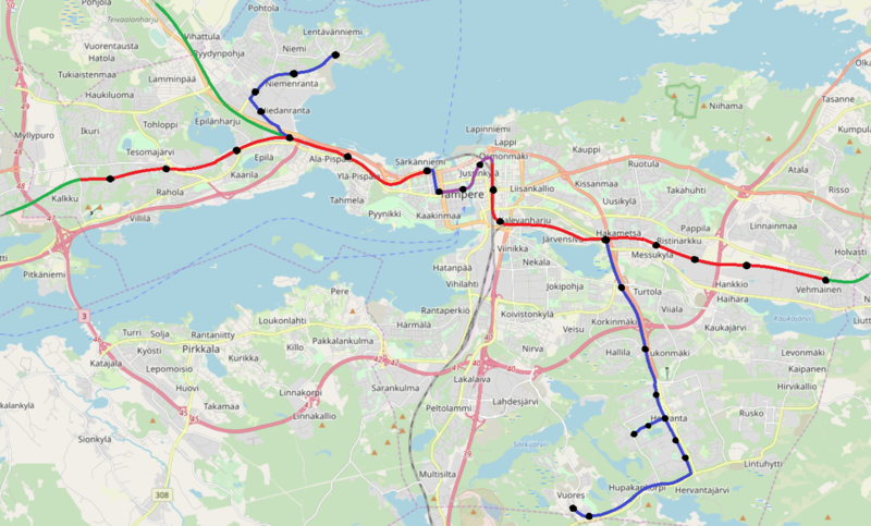
Suomi: Kartassa on kuvattu suunnitellut ensimmäisen vaiheen pikaraitiotielinjat Tampereen seudulla. Punainen osuus tarkoittaa valtion rataverkkoa käyttävää linjausta, sininen erillistä maanpäällistä rataa, violetti keskustan tunneliosuutta sekä mustat pisteet pysäkkejä. Vihreät osuudet merkitsevät Kangasalan, Nokian ja Ylöjärven suuntiin tehtäviä laajennuksia tai ruuhka-ajan liikennettä. |
| Date | |
| Source | Own work |
| Author | Dankos10 |
| Permission (Reusing this file) |
© OpenStreetMap |
Licensing[edit]
I, the copyright holder of this work, hereby publish it under the following license:
This file is licensed under the Creative Commons Attribution-Share Alike 2.0 Generic license.
- You are free:
- to share – to copy, distribute and transmit the work
- to remix – to adapt the work
- Under the following conditions:
- attribution – You must give appropriate credit, provide a link to the license, and indicate if changes were made. You may do so in any reasonable manner, but not in any way that suggests the licensor endorses you or your use.
- share alike – If you remix, transform, or build upon the material, you must distribute your contributions under the same or compatible license as the original.
File history
Click on a date/time to view the file as it appeared at that time.
| Date/Time | Thumbnail | Dimensions | User | Comment | |
|---|---|---|---|---|---|
| current | 20:21, 19 October 2020 | | 1,395 × 842 (1.37 MB) | Dankos10 (talk | contribs) | Pientä hienosäätöä ratalinjaukseen |
| 21:25, 17 March 2019 |  | 1,395 × 842 (1.22 MB) | Dankos10 (talk | contribs) | User created page with UploadWizard |
You cannot overwrite this file.
File usage on Commons
The following 8 pages use this file:
- User:Apalsola/recent uploads/Rail transport in Finland/2019 March 11-20
- User:Apalsola/recent uploads/Rail transport in Finland/2020 October 11-20
- User:Chumwa/OgreBot/Potential transport maps/2019 March 11-20
- User:Chumwa/OgreBot/Public transport information/2019 March 11-20
- User:Chumwa/OgreBot/Public transport information/2020 October 11-20
- User:Chumwa/OgreBot/Transport Maps/2019 March 11-20
- User:Chumwa/OgreBot/Transport Maps/2020 October 11-20
- User:Chumwa/OgreBot/Travel and communication maps/2019 March 11-20
File usage on other wikis
The following other wikis use this file:
- Usage on fi.wikipedia.org
- Usage on sv.wikipedia.org