File:TABULA AMERICÆ SPECIALIS GEOGRAPHICA REGNI PERU, BRAZILIÆ, TERRÆ FIRMÆ &Reg AMAZONUM - Guillaume de L'Isle, c. 1729 - BL Maps K.Top.124.16 (BLL01018640916).jpg
Original file (7,283 × 5,961 pixels, file size: 10.47 MB, MIME type: image/jpeg)
Captions
Captions
| Title |
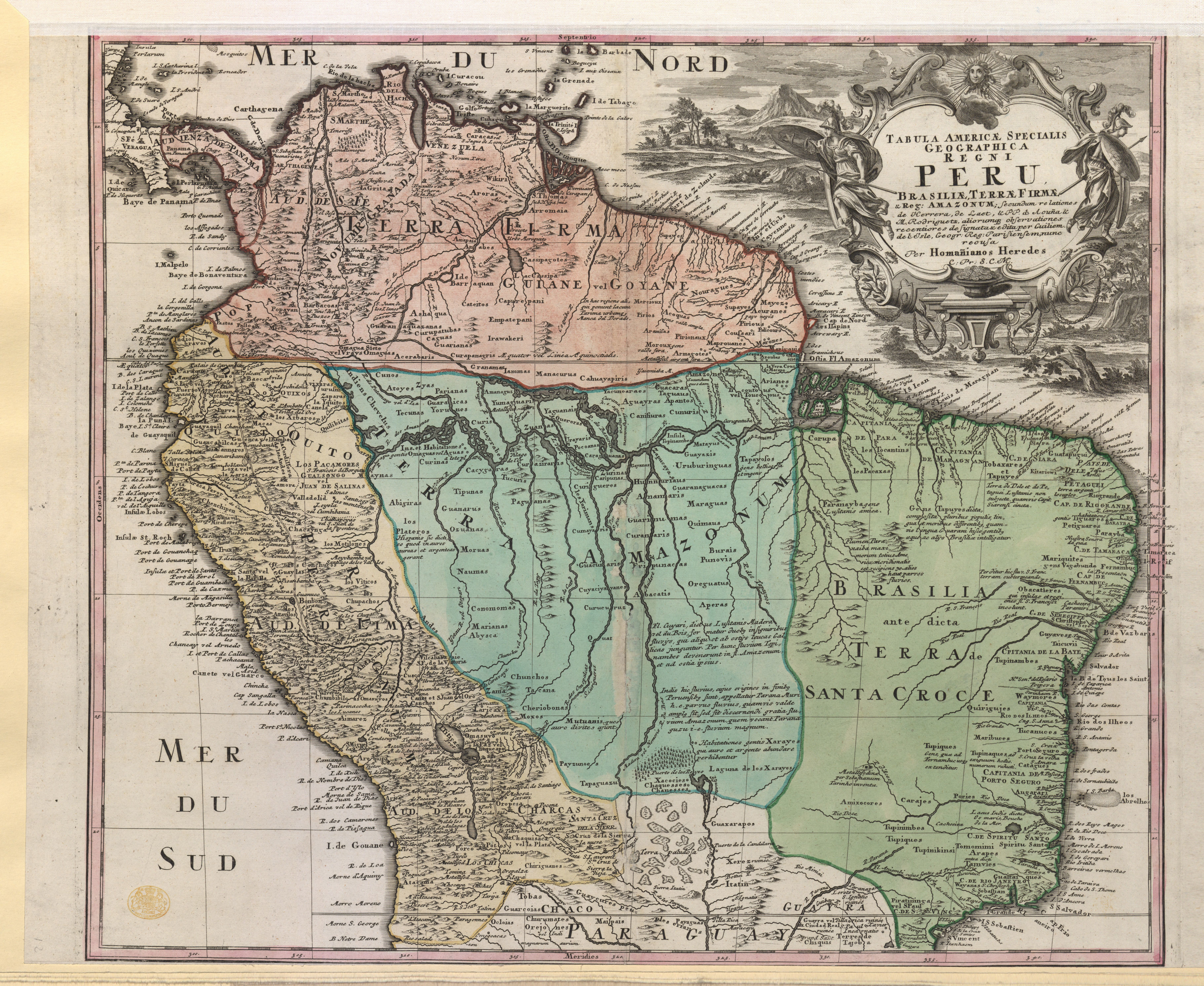
Latina: TABULA AMERICÆ SPECIALIS GEOGRAPHICA REGNI PERU, BRAZILIÆ, TERRÆ FIRMÆ &Reg: AMAZONUM; : Secundum relationes de Herrera, de Laet, & PP. d'Acuña & M. Rodriguetz, aliorumq. observationes / recentiores designata & edita per Guiliem. de l'Isle, Geogr: Reg: Parisiensem, nunc recusa Per Homañinos Heredes C: Pr: S.C.M. |
|||||||||||||||||||||||
| Description |
English: Homan Heirs' edition of Guillaume de L'Isle's map, state with topographical scenes added to the cartouche. State not in: Homann Heirs' "Atlas mapparum geographicarum generalium & specialium", [1728-1793] (Phillips, P.L., A list of geographical atlases in the Library of Congress, volume I, entries 623, 624 and 1793). The state included in the atlases is the one without the topographical scenes surrounding the cartouche. Dated [1735?] in a previous catalogue. Dated in line with the date of the privilege (14/06/1729) granted to Homan Heirs (M., Diefenbacher, M., Heinz and R. Bach-Damaskinos, "auserlesene und allerneueste Landkarten" Der Verlag Homann in Nürnberg 1702-1848, page 261). |
|||||||||||||||||||||||
| Date | circa 1729 | |||||||||||||||||||||||
| Source |
Part of King George III's Topographical Collection. Donated to the nation by George IV. Please do not overwrite this file. Any cropped or modified version should be uploaded with a new name and linked in the "
|
|||||||||||||||||||||||
| Creator |
Cartographer:
|
|||||||||||||||||||||||
| Permission (Reusing this file) |
|
|||||||||||||||||||||||
| Geotemporal data | ||||||||||||||||||||||||
| Map location |
Brazil |
|||||||||||||||||||||||
| Scale | 1:9,500,000 | |||||||||||||||||||||||
| OpenStreetMap zoom level | 3 | |||||||||||||||||||||||
| Bounding box |
|
|||||||||||||||||||||||
| Georeferencing | If inappropriate please set warp_status = skip to hide. | |||||||||||||||||||||||
| Bibliographic data | ||||||||||||||||||||||||
| Language | Latin | |||||||||||||||||||||||
| Place of publication | [Nuremberg] : [Homann Erben (Firm)] | |||||||||||||||||||||||
| Archival data | ||||||||||||||||||||||||
| Collection | ||||||||||||||||||||||||
| Accession number |
British Library Maps K.Top.124.16 |
|||||||||||||||||||||||
| Dimensions | height: 46 cm (18.1 in); width: 54 cm (21.2 in) | |||||||||||||||||||||||
| Metadata note | Initial version of this page based on information from the BL catalogue entry, updated 2017-12-08. Used with permission. Accessed 2018-09-18. | |||||||||||||||||||||||


File history
Click on a date/time to view the file as it appeared at that time.
| Date/Time | Thumbnail | Dimensions | User | Comment | |
|---|---|---|---|---|---|
| current | 11:43, 22 September 2018 | | 7,283 × 5,961 (10.47 MB) | JhealdBot (talk | contribs) | JhealdBot(6): test upload |
You cannot overwrite this file.
File usage on Commons
The following page uses this file:
.jpg)
.jpg&oldid=818116769)