File:Synod of the Trinity map - border.svg
Jump to navigation
Jump to search

Size of this PNG preview of this SVG file: 159 × 137 pixels. Other resolutions: 279 × 240 pixels | 557 × 480 pixels | 891 × 768 pixels | 1,189 × 1,024 pixels | 2,377 × 2,048 pixels.
Original file (SVG file, nominally 159 × 137 pixels, file size: 208 KB)
Captions
Captions
Add a one-line explanation of what this file represents
| Description |
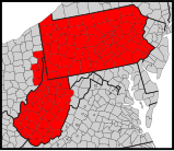
English: Map of counties in the Synod of the Trinity. |
| Date | (UTC) |
| Source | |
| Author |
|
| Other versions |
Derivative works of this file: |
| This is a retouched picture, which means that it has been digitally altered from its original version. Modifications: Modify map. The original can be viewed here: Usa counties large.svg:
|
This image or file is a work of a United States Census Bureau employee, taken or made as part of that person's official duties. As a work of the U.S. federal government, the image is in the public domain.
|
 |
This W3C-unspecified vector image was created with Inkscape .
Original upload log[edit]
This image is a derivative work of the following images:
- File:Usa_counties_large.svg licensed with PD-USGov-DOC-Census
- 2010-02-07T00:27:18Z Abe.suleiman 990x627 (1727952 Bytes) {{Information |Description={{en|This is a map of the [[United States]] showing the borders of states and counties in high detail.}} |Source=*[[:File:USA_Counties.svg|]] |Date=2010-02-07 00:19 (UTC) |Author=*[[:File:USA_Counti
Uploaded with derivativeFX
File history
Click on a date/time to view the file as it appeared at that time.
| Date/Time | Thumbnail | Dimensions | User | Comment | |
|---|---|---|---|---|---|
| current | 23:12, 20 April 2011 | | 159 × 137 (208 KB) | GrapedApe (talk | contribs) | fix a different border problem |
| 23:07, 20 April 2011 |  | 159 × 137 (208 KB) | GrapedApe (talk | contribs) | fix border thingy | |
| 03:06, 20 April 2011 |  | 159 × 137 (207 KB) | GrapedApe (talk | contribs) | {{Information |Description={{en|Map of counties in the {{w|Synod of the Trinity}}.}} |Source=*File:Usa_counties_large.svg |Date=2011-04-20 03:05 (UTC) |Author=*File:Usa_counties_large.svg: *USA_Counties.svg: [http:// |
You cannot overwrite this file.
File usage on Commons
The following 2 pages use this file:
File usage on other wikis
The following other wikis use this file:
- Usage on en.wikipedia.org