File:Syndicat mixte Autolib map.svg
Jump to navigation
Jump to search

Size of this PNG preview of this SVG file: 587 × 600 pixels. Other resolutions: 235 × 240 pixels | 470 × 480 pixels | 752 × 768 pixels | 1,002 × 1,024 pixels | 2,004 × 2,048 pixels | 1,552 × 1,586 pixels.
Original file (SVG file, nominally 1,552 × 1,586 pixels, file size: 541 KB)
Captions
Captions
Add a one-line explanation of what this file represents
Summary[edit]
| Description |
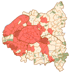
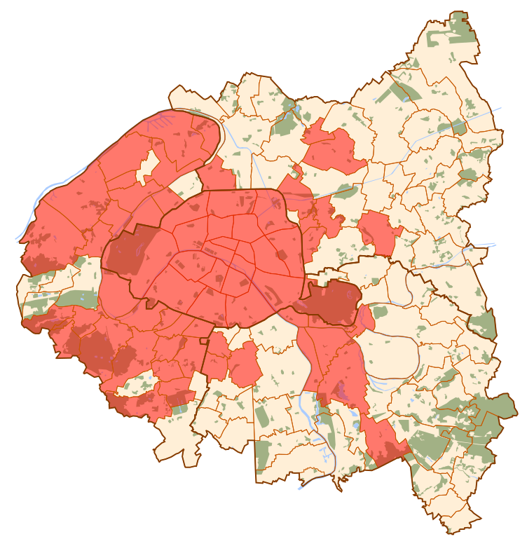
English: Map of the municipalities involved in the Autolib' project
Français : Carte des communes participant au projet Autolib' |
| Date | |
| Source | Own work |
| Author | Zejeremius |
Licensing[edit]
| I, the copyright holder of this work, release this work into the public domain. This applies worldwide. In some countries this may not be legally possible; if so: I grant anyone the right to use this work for any purpose, without any conditions, unless such conditions are required by law. |
File history
Click on a date/time to view the file as it appeared at that time.
| Date/Time | Thumbnail | Dimensions | User | Comment | |
|---|---|---|---|---|---|
| current | 17:37, 13 September 2012 | | 1,552 × 1,586 (541 KB) | Zejeremius (talk | contribs) | City of Rosny-sous-Bois added. |
| 18:11, 11 March 2011 |  | 1,552 × 1,586 (541 KB) | Zejeremius (talk | contribs) | City of Colombes added. | |
| 13:47, 19 February 2011 |  | 1,552 × 1,586 (541 KB) | Zejeremius (talk | contribs) | Cities of Châtenay-Malabry, Rueil-Malmaison and Suresnes added. | |
| 19:35, 15 January 2011 |  | 1,552 × 1,586 (541 KB) | Zejeremius (talk | contribs) | City of Gennevilliers added. | |
| 00:38, 20 December 2010 |  | 1,552 × 1,586 (541 KB) | Zejeremius (talk | contribs) | City of Puteaux added. | |
| 00:06, 15 December 2010 |  | 1,552 × 1,586 (541 KB) | Zejeremius (talk | contribs) | City of Saint-Ouen added. | |
| 22:55, 5 December 2010 |  | 1,552 × 1,586 (541 KB) | Zejeremius (talk | contribs) | City of Joinville-le-Pont added. | |
| 02:18, 28 November 2010 |  | 1,552 × 1,586 (541 KB) | Zejeremius (talk | contribs) | City of Châtillon added. | |
| 00:45, 2 November 2010 |  | 1,552 × 1,586 (541 KB) | Zejeremius (talk | contribs) | {{Information |Description={{en|1=Map of the municipalities involved in the Autolib' project}} {{fr|1=Carte des communes participant au projet Autolib'}} |Source={{own}} |Author=Zejeremius |Date=2010-11-01 |Permission= |other_versions= |
You cannot overwrite this file.
File usage on Commons
There are no pages that use this file.
File usage on other wikis
The following other wikis use this file:
- Usage on es.wikipedia.org
- Usage on fr.wikipedia.org