File:Sykes-picot.png
Jump to navigation
Jump to search
No higher resolution available.
Sykes-picot.png (704 × 585 pixels, file size: 597 KB, MIME type: image/png)
Captions
Captions
Add a one-line explanation of what this file represents
Summary[edit]
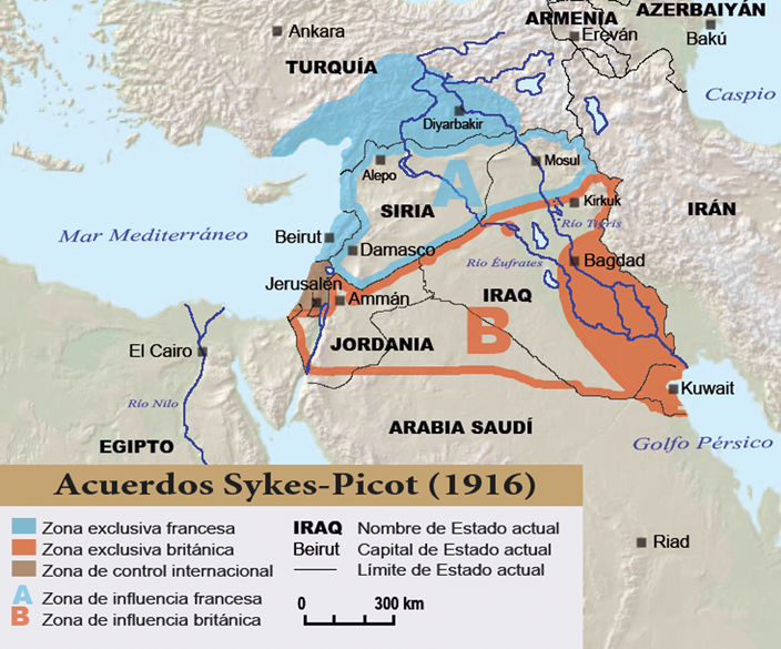
Mapa de los acuerdos Sykes-Picot de 1916 sobre el reparto de Oriente Medio. Autor Degeefe @ es.wikipedia.org sobre un mapa en blanco del dominio público (CIA)
Licensing[edit]
| |
This work has been released into the public domain by its author, degeefe, at the English Wikipedia project. This applies worldwide. In case this is not legally possible: |
File history
Click on a date/time to view the file as it appeared at that time.
| Date/Time | Thumbnail | Dimensions | User | Comment | |
|---|---|---|---|---|---|
| current | 18:16, 31 January 2006 | | 704 × 585 (597 KB) | Degeefe (talk | contribs) | |
| 01:44, 31 January 2006 |  | 704 × 585 (597 KB) | Degeefe (talk | contribs) | Acuerdos Sykes-Picot de 1916 sobre el reparto de Oriente Medio. Autor degeefe @ es.wikipedia.org sobre un mapa blanco del dominio público (CIA) | |
| 01:40, 31 January 2006 |  | 733 × 609 (560 KB) | Degeefe (talk | contribs) | Mapa de los acuerdos Sykes-Picot de 1916 sobre el reparto de Oriente Medio. Autor Degeefe @ es.wikipedia.org sobre un mapa en blanco del dominio público (CIA) |
You cannot overwrite this file.
File usage on Commons
There are no pages that use this file.
File usage on other wikis
The following other wikis use this file:
- Usage on ca.wikipedia.org
- Usage on da.wikipedia.org
- Usage on eo.wikipedia.org
- Usage on es.wikipedia.org
- Usage on gl.wikipedia.org
- Usage on nl.wikipedia.org
- Usage on no.wikipedia.org
- Usage on pl.wikipedia.org
- Usage on sv.wikipedia.org