File:Sumas panorama.jpg
Jump to navigation
Jump to search

Size of this preview: 798 × 129 pixels. Other resolutions: 320 × 52 pixels | 640 × 104 pixels | 1,024 × 166 pixels | 1,280 × 207 pixels | 2,560 × 414 pixels | 14,565 × 2,356 pixels.
Original file (14,565 × 2,356 pixels, file size: 44.83 MB, MIME type: image/jpeg)
Captions
Captions
Add a one-line explanation of what this file represents
Summary[edit]
| Description |
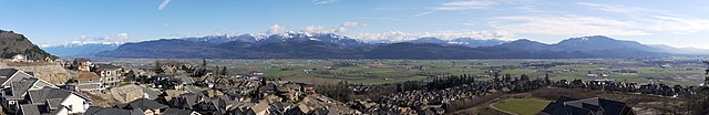
English: View of Abbotsford, BC and Sumas Prairie looking southeast from Eagle Mountain (Lower Sumas Mountain), Abbotsford, BC, Canada. Observe Mount Baker, partially obscured by clouds, in the distance. Eagle Mountain is not to be confused with Eagle Mountain in Coquitlam, BC. |
| Date | Taken on 21 February 2013, 14:31:33 |
| Source | Own work |
| Author | Purpy Pupple |
| Other versions |
   |
| Camera location | | View this and other nearby images on: OpenStreetMap |
|---|

|
NOTE: This image is a panorama consisting of multiple frames that were merged or stitched in software. As a result, this image necessarily underwent some form of digital manipulation. These manipulations may include blending, blurring, cloning, and colour and perspective adjustments. As a result of these adjustments, the image content may be slightly different from reality at the points where multiple images were combined. This manipulation is often required due to lens, perspective, and parallax distortions.
|
Panorama stitched from six frames, each of which was shot with three exposures (+2 ev, 0 ev, -2 ev). Each frame was captured with a Canon EOS 1000D with a Tamron SP AF17–50mm f/2.8 XR Di II VC LD Aspherical (IF) lens at 34 mm. Aperture set at f/8; shutter speeds were 1/60 s, 1/250 s, and 1/1000 s for the three exposures respectively. Approximate horizontal field of view 142 degrees; vertical field of view 26 degrees. Image tone-mapped from HDR image (see EXIF).
Licensing[edit]
I, the copyright holder of this work, hereby publish it under the following license:
This file is licensed under the Creative Commons Attribution-Share Alike 3.0 Unported license.
- You are free:
- to share – to copy, distribute and transmit the work
- to remix – to adapt the work
- Under the following conditions:
- attribution – You must give appropriate credit, provide a link to the license, and indicate if changes were made. You may do so in any reasonable manner, but not in any way that suggests the licensor endorses you or your use.
- share alike – If you remix, transform, or build upon the material, you must distribute your contributions under the same or compatible license as the original.
This image has been assessed using the Quality image guidelines and is considered a Quality image.
|
File history
Click on a date/time to view the file as it appeared at that time.
| Date/Time | Thumbnail | Dimensions | User | Comment | |
|---|---|---|---|---|---|
| current | 02:32, 28 February 2013 | 14,565 × 2,356 (44.83 MB) | Dllu (talk | contribs) | Sharpened; cropped bottom to remove some black edges. | |
| 22:24, 22 February 2013 | 14,565 × 2,370 (36.87 MB) | Dllu (talk | contribs) | Bigger size, slightly different saturation and levels. | ||
| 22:44, 21 February 2013 | 10,196 × 1,659 (20.1 MB) | Dllu (talk | contribs) | User created page with UploadWizard |
You cannot overwrite this file.
File usage on Commons
The following 7 pages use this file:
File usage on other wikis
The following other wikis use this file:
- Usage on en.wikipedia.org