File:Sultan Mahmud Bendi.jpg
Original file (4,032 × 3,024 pixels, file size: 5.5 MB, MIME type: image/jpeg)
Captions
Summary[edit]
DescriptionSultan Mahmud Bendi.jpg |
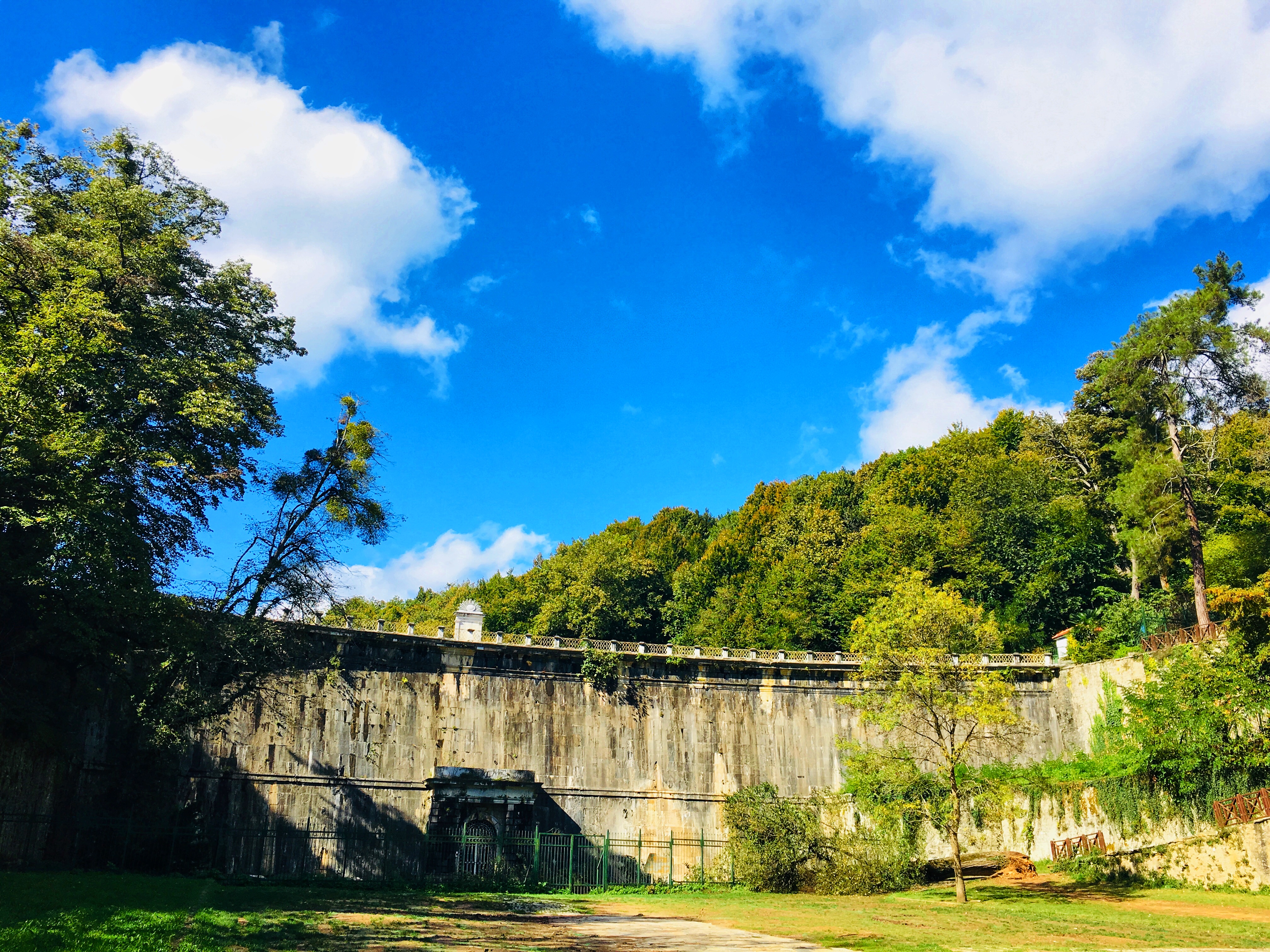
English: Belgrad forest is a unique place where history meets nature. This masterpiece, located in the Belgrade forest, was built by Sultan II. It was built by Mahmud in 1839 to meet the increasing water requirement.
Türkçe: Belgrad ormanı tarihin doğayla buluştuğu eşsiz bir yer. Belgrad ormanın içinde bulunan bu şaheser, Sultan II. Mahmud tarafından artan su gereksiniminin karşılanması için 1839 yılında inşa ettirilmiştir. |
Date | |
Source | Own work |
Author | Beyza Küçük |
Camera location | 41° 11′ 21.45″ N, 28° 59′ 12.11″ E | View this and other nearby images on: OpenStreetMap | 41.189292; 28.986697 |
---|
Licensing[edit]
- You are free:
- to share – to copy, distribute and transmit the work
- to remix – to adapt the work
- Under the following conditions:
- attribution – You must give appropriate credit, provide a link to the license, and indicate if changes were made. You may do so in any reasonable manner, but not in any way that suggests the licensor endorses you or your use.
- share alike – If you remix, transform, or build upon the material, you must distribute your contributions under the same or compatible license as the original.
This image was uploaded as part of Wiki Loves Earth 2021.
aragonés ∙ asturianu ∙ azərbaycanca ∙ Bahasa Indonesia ∙ Bahasa Melayu ∙ brezhoneg ∙ català ∙ čeština ∙ Cymraeg ∙ Deutsch ∙ eesti ∙ English ∙ español ∙ euskara ∙ français ∙ galego ∙ hrvatski ∙ italiano ∙ latviešu ∙ Nederlands ∙ norsk ∙ norsk bokmål ∙ português ∙ polski ∙ português do Brasil ∙ română ∙ shqip ∙ sicilianu ∙ slovenščina ∙ svenska ∙ Türkçe ∙ Ελληνικά ∙ беларуская (тарашкевіца) ∙ български ∙ македонски ∙ русский ∙ српски / srpski ∙ українська ∙ ქართული ∙ հայերեն ∙ नेपाली ∙ मराठी ∙ বাংলা ∙ മലയാളം ∙ ไทย ∙ 한국어 ∙ 日本語 ∙ 中文 ∙ 中文(台灣) ∙ 中文(简体) ∙ 中文(繁體) ∙ עברית ∙ اردو ∙ العربية ∙ فارسی ∙ +/− |
File history
Click on a date/time to view the file as it appeared at that time.
Date/Time | Thumbnail | Dimensions | User | Comment | |
---|---|---|---|---|---|
current | 21:14, 6 June 2021 | 4,032 × 3,024 (5.5 MB) | Beyza Küçük (talk | contribs) | Uploaded own work with UploadWizard |
You cannot overwrite this file.
File usage on Commons
There are no pages that use this file.
Metadata
This file contains additional information such as Exif metadata which may have been added by the digital camera, scanner, or software program used to create or digitize it. If the file has been modified from its original state, some details such as the timestamp may not fully reflect those of the original file. The timestamp is only as accurate as the clock in the camera, and it may be completely wrong.
Camera manufacturer | Apple |
---|---|
Camera model | iPhone 6s |
Exposure time | 1/1,026 sec (0.00097465886939571) |
F-number | f/2.2 |
ISO speed rating | 25 |
Date and time of data generation | 13:37, 9 October 2019 |
Lens focal length | 4.15 mm |
Latitude | 41° 11′ 21.45″ N |
Longitude | 28° 59′ 12.11″ E |
Altitude | 149.683 meters above sea level |
Horizontal resolution | 72 dpi |
Vertical resolution | 72 dpi |
Software used | Snapseed 2.19.272140074 |
File change date and time | 13:37, 9 October 2019 |
Y and C positioning | Centered |
Exposure Program | Normal program |
Exif version | 2.21 |
Date and time of digitizing | 13:37, 9 October 2019 |
Meaning of each component |
|
APEX shutter speed | 10.002310164725 |
APEX aperture | 2.2750070480205 |
APEX brightness | 9.6614102049016 |
APEX exposure bias | 0.25738784259685 |
Metering mode | Spot |
Flash | Flash did not fire, compulsory flash suppression |
DateTimeOriginal subseconds | 329 |
DateTimeDigitized subseconds | 329 |
Supported Flashpix version | 1 |
Color space | sRGB |
Sensing method | One-chip color area sensor |
Scene type | A directly photographed image |
Exposure mode | Auto exposure |
White balance | Auto white balance |
Focal length in 35 mm film | 29 mm |
Scene capture type | Standard |
GPS time (atomic clock) | 10:37 |
Speed unit | Kilometers per hour |
Speed of GPS receiver | 0 |
Reference for direction of image | True direction |
Direction of image | 325.64227292294 |
Reference for bearing of destination | True direction |
Bearing of destination | 325.64227292294 |
GPS date | 9 October 2019 |
Structured data
9 October 2019
41°11'21.451"N, 28°59'12.109"E
0.0009746588693957115 second
2.2
4.15 millimetre
- Files with coordinates missing SDC location of creation
- CC-BY-SA-4.0
- Self-published work
- Images from Wiki Loves Earth 2021
- Images from Wiki Loves Earth 2021 in Turkey
- Images from Wiki Loves Earth missing SDC location of creation
- Images from Wiki Loves Earth missing SDC creator
- Uploaded via Campaign:wle-tr
- Pages with maps