File:Sulby Bridge Railway Station (geograph 2180512).jpg
Jump to navigation
Jump to search

Size of this preview: 715 × 599 pixels. Other resolutions: 286 × 240 pixels | 573 × 480 pixels | 916 × 768 pixels.
Original file (916 × 768 pixels, file size: 187 KB, MIME type: image/jpeg)
Captions
Captions
Add a one-line explanation of what this file represents
Summary[edit]
.jpg&action=edit§ion=1)
| Description |
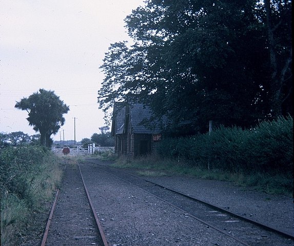
English: Sulby Bridge Railway Station Situated on the A17 road near Sulby, this station was on the 3ft gauge Isle of Man Railway line between Ramsey and St John's, which closed in September, 1968 two years before the photo was taken. The track has since been taken up, although traces of it can still be seen today. |
| Date | |
| Source | From geograph.org.uk |
| Author | David Hillas |
| Permission (Reusing this file) |
Creative Commons Attribution Share-alike license 2.0 |
| Attribution (required by the license) | David Hillas / Sulby Bridge Railway Station / |
| Camera location | | View this and other nearby images on: OpenStreetMap |
|---|
.jpg¶ms=054.324182_N_-004.473877_E_globe:Earth_type:camera_source:geograph-osgb36(SC39219489)_heading:67.00&language=en)
| Object location | | View this and other nearby images on: OpenStreetMap |
|---|
.jpg¶ms=054.324280_N_-004.473270_E_globe:Earth_class:object_type:object_source:geograph-osgb36(SC39259490)_heading:67.00&language=en)
Licensing[edit]
.jpg&action=edit§ion=2)

|
This image was taken from the Geograph project collection. See this photograph's page on the Geograph website for the photographer's contact details. The copyright on this image is owned by David Hillas and is licensed for reuse under the Creative Commons Attribution-ShareAlike 2.0 license.
|
This file is licensed under the Creative Commons Attribution-Share Alike 2.0 Generic license.
Attribution: David Hillas
- You are free:
- to share – to copy, distribute and transmit the work
- to remix – to adapt the work
- Under the following conditions:
- attribution – You must give appropriate credit, provide a link to the license, and indicate if changes were made. You may do so in any reasonable manner, but not in any way that suggests the licensor endorses you or your use.
- share alike – If you remix, transform, or build upon the material, you must distribute your contributions under the same or compatible license as the original.
File history
Click on a date/time to view the file as it appeared at that time.
| Date/Time | Thumbnail | Dimensions | User | Comment | |
|---|---|---|---|---|---|
| current | 18:37, 11 April 2021 | | 916 × 768 (187 KB) | Lamberhurst (talk | contribs) | Transferred from geograph.co.uk using [https://tools.wmflabs.org/geograph2commons/ geograph2commons] |
You cannot overwrite this file.
File usage on Commons
There are no pages that use this file.
.jpg&oldid=671519855)