File:Stuttgart Rossebändiger-Gruppe Skulptur 1.JPG
Jump to navigation
Jump to search

Size of this preview: 400 × 600 pixels. Other resolutions: 160 × 240 pixels | 320 × 480 pixels | 512 × 768 pixels | 682 × 1,024 pixels | 2,304 × 3,456 pixels.
Original file (2,304 × 3,456 pixels, file size: 4.04 MB, MIME type: image/jpeg)
Captions
Captions
Add a one-line explanation of what this file represents
Summary[edit]
| Description |
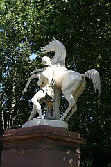
Deutsch: Eine dera us zwei Skulpturen bestehende Rossebändiger-Gruppe am Eingang der Platanenallee zum Schloss Rosenstein im Unteren Schlossgarten in Stuttgart. Geschaffen 1844 bis 1847 aus Carraramarmor vom Hofbildhauer Luwig von Hofer. Stadtbezirk Stuttgart-Ost, Baden-Württemberg, Deutschland. English: One of the horse tamer's group existing of two sculptures at the entrance of the plane tree avenue to the castle Rose stone in the lower castle garden in Stuttgart. Created from 1844 to 1847 from Carraramarmor of the court sculptor Ludwig von Hofer. Town district the Stuttgart east, Baden-Wurttemberg, Germany. Français : L'un du groupe volumes de chevaux se composant de deux sculptures à l'entrée de l'allée de platanes au château Pierre de roses dans le jardin du château inférieur à Stuttgart. De manière créée de 1844 à 1847 de Carraramarmor du sculpteur de cour Luwig de Hofer. Arrondissement de ville l'est de Stuttgart, Baden-Wurtemberg, l'Allemagne. Español: Uno del Rossebändiger grupo que existe de dos esculturas en la entrada del paseo de plátanos al castillo Piedra de rosas en el jardín de castillo inferior en Stuttgart. De modo creado de 1844 a 1847 de Carraramarmor del escultor de patio Luwig von Hofer. Distrito municipal el este de Stuttgart, Baden-Wurtemberg, Alemania. Русский: Одна из существующей из 2 скульптур томной группы коней у входа аллеи платанов в замок Камень роз в Нижнем замковом саду в Штутгарте. Создано с 1844 по 1847 из Carraramarmor от придворного скульптора Лувига фон Гофер. Городской район восток Штутгарта, Баден-Вюртемберг, Германию.
| ||
| Address |
|
||
| Date | |||
| Source | Own work | ||
| Author | MSeses | ||
| Attribution (required by the license) | © MSeses / Wikimedia Commons / | ||
| Object location | | View this and other nearby images on: OpenStreetMap |
|---|
Licensing[edit]
I, the copyright holder of this work, hereby publish it under the following license:
This file is licensed under the Creative Commons Attribution-Share Alike 3.0 Unported license.
- You are free:
- to share – to copy, distribute and transmit the work
- to remix – to adapt the work
- Under the following conditions:
- attribution – You must give appropriate credit, provide a link to the license, and indicate if changes were made. You may do so in any reasonable manner, but not in any way that suggests the licensor endorses you or your use.
- share alike – If you remix, transform, or build upon the material, you must distribute your contributions under the same or compatible license as the original.

|
This image was uploaded as part of Wiki Loves Monuments 2012.
|
File history
Click on a date/time to view the file as it appeared at that time.
| Date/Time | Thumbnail | Dimensions | User | Comment | |
|---|---|---|---|---|---|
| current | 12:56, 1 September 2012 | | 2,304 × 3,456 (4.04 MB) | MSeses (talk | contribs) | User created page with UploadWizard |
You cannot overwrite this file.
File usage on Commons
The following 2 pages use this file:
File usage on other wikis
The following other wikis use this file:
- Usage on de.wikipedia.org