File:Statehood quarters map 2009.svg
Jump to navigation
Jump to search

Size of this PNG preview of this SVG file: 800 × 495 pixels. Other resolutions: 320 × 198 pixels | 640 × 396 pixels | 1,024 × 633 pixels | 1,280 × 791 pixels | 2,560 × 1,583 pixels | 959 × 593 pixels.
Original file (SVG file, nominally 959 × 593 pixels, file size: 113 KB)
Captions
Captions
Add a one-line explanation of what this file represents
Summary[edit]
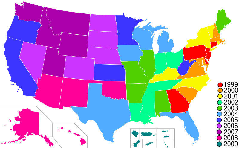
| Description | Map of Statehood quarters with the 2009 issues |
| Date | |
| Source | base map is Lokal_Profil's blank map of US with territories; color scheme and the key is from the png version of this map by me. Guam has been redone based on Image:Guam-CIA WFB Map.png. American Samoa has been added based on Image:American Samoa-CIA WFB Map.png |
| Author | Hoshie |
Licensing[edit]
I, the copyright holder of this work, hereby publish it under the following license:

|
Permission is granted to copy, distribute and/or modify this document under the terms of the GNU Free Documentation License, Version 1.2 or any later version published by the Free Software Foundation; with no Invariant Sections, no Front-Cover Texts, and no Back-Cover Texts. A copy of the license is included in the section entitled GNU Free Documentation License. |
| This file is licensed under the Creative Commons Attribution-Share Alike 3.0 Unported license. | ||
| ||
| This licensing tag was added to this file as part of the GFDL licensing update. |
File history
Click on a date/time to view the file as it appeared at that time.
| Date/Time | Thumbnail | Dimensions | User | Comment | |
|---|---|---|---|---|---|
| current | 02:28, 30 January 2009 | | 959 × 593 (113 KB) | Hoshie (talk | contribs) | move DC inset to the bottom with the others |
| 23:33, 18 January 2009 |  | 959 × 593 (112 KB) | Hoshie (talk | contribs) | Made DC an inset; fixed Tutuila (American Samoa) | |
| 05:08, 13 January 2009 |  | 959 × 593 (112 KB) | Hoshie (talk | contribs) | {{Information |Description=Map of Statehood quarters with the 2009 issues |Source=base map is Lokal_Profil's blank map of US with territories; color scheme and the key is from the [[:Image:Stat |
You cannot overwrite this file.
File usage on Commons
The following page uses this file:
File usage on other wikis
The following other wikis use this file:
- Usage on ar.wikipedia.org
- Usage on de.wikipedia.org
- Usage on en.wikipedia.org
- Usage on es.wikipedia.org
- Usage on fr.wikipedia.org
- Usage on gl.wikipedia.org
- Usage on it.wikipedia.org
- Usage on ja.wikipedia.org
- Usage on ko.wikipedia.org
- Usage on nl.wikipedia.org
- Usage on ru.wikipedia.org
- Usage on uk.wikipedia.org
- Usage on zh.wikipedia.org